The Appalachian Trail is the most famous hiking footpath in the world, drawing more than 16.9 million visits each year and inspiring millions more through the scope of this ever-growing project in environmental conservation and outdoor recreation. Yet even though the Trail is popular, there is a lot to decode when it comes to the Trail, how it’s maintained and protected, and how to enjoy it safely and sustainably.
Whether you’ve never set foot on the A.T. or you have hiked the entire length of the Trail (maybe more than once!), there is always more to learn about the A.T. and the groups like the Appalachian Trail Conservancy who have pledged to protect it. Below are some of the most common questions we have received about the A.T. and the ATC.
Last updated: July 17, 2023
General Information About the A.T. and the ATC
The Appalachian National Scenic Trail — more commonly known as the Appalachian Trail or “the A.T.” — is a unit of the National Park System. Fully connected in 1937, the A.T. stretches from its northern terminus at Katahdin, Maine, to its southern terminus at Springer Mountain, Georgia. At more than 2,190 miles in length, the A.T. is the world’s longest hiking-only footpath. People from across the globe are drawn to the A.T. for a variety of reasons, such as reconnecting with nature, escaping the stress of city life, meeting new people or deepening old friendships, or experiencing a simpler life.
The northern terminus of the A.T. is the summit of Katahdin in Maine’s Baxter State Park. The southern terminus is Springer Mountain in the Chattahoochee-Oconee National Forest in Georgia. The Trail also winds through New Hampshire, Vermont, Massachusetts, Connecticut, New York, New Jersey, Pennsylvania, Maryland, West Virginia, Virginia, Tennessee, and North Carolina — 14 states in total. Explore the Trail, including scenic views, parking areas, and campsite locations, by using our interactive map.
The length of the A.T. changes slightly from year to year. This is primarily due to relocations to help make the A.T. as sustainable and resilient as possible while maintaining the Trail’s wild character. Sections of the Trail are also regularly remeasured with more precise equipment and techniques to be as accurate as possible.
Visit our For Press page to learn the current length of the Trail (and other fun Trail facts!) and read more about the A.T. in each state here.
As a National Scenic Trail and unit of the National Park System, the A.T. is administered by the Appalachian National Scenic Trail office of the National Park Service (APPA). However, the A.T. has a unique Cooperative Management System, coordinated by the Appalachian Trail Conservancy, that involves other federal agencies, like the U.S. Forest Service, state and local land managers whose land the A.T. traverses, and 30 local A.T. Maintaining Clubs that maintain the Trail.
Read more about the history of the Trail and ATC here.
Established in 1925, the Appalachian Trail Conservancy is the leading organization in charge of protecting, managing, and advocating for the entire 2,000+ mile Appalachian Trail and its surrounding lands. Tasked by Congress to oversee the Trail, the ATC has a hand in every aspect of ensuring the Trail continues to be a source of recreation, inspiration, and environmental conservation for centuries to come.
The work of the ATC covers ranges from on-the-ground Trail maintenance to comprehensive administrative coordination to ensure the holistic needs of the A.T. are met. The following are just a few of the responsibilities that the ATC fulfills:
- The ATC unites land management agencies and A.T. Maintaining Clubs, ensuring Trail-wide consistency in upholding the natural and cultural values for which the Trail is protected while keeping volunteers at the forefront of A.T. management.
- The ATC acts similarly in our land conservation work — uniting land management agencies, local organizations, volunteers, and land trusts to conserve the critical but threatened Appalachian landscape. Read more about our landscape conservation efforts here.
- The ATC provides educational and up-to-date information about the Trail so every visitor can help steward this special resource and have a safe, enjoyable visit to the A.T.
- The ATC Science and Stewardship team helps ensure the A.T. and its surrounding lands are conserved and healthy. This includes combating invasive species, improving and protecting key habitats for native plants and animals, and reinforcing the climate resiliency of A.T. lands.
The Appalachian Trail is a unit of the National Park System, and the ATC operates as a public-private partnership with a variety of Federal, state, and local stakeholders. Public funding covers specific costs associated with the maintenance of the footpath. However, support from generous individuals, foundations, and corporations are what enable us to continue our critically important conservation work at a large scale from Maine to Georgia. These private dollars are critical to our vision of permanently protecting the Appalachian Trail and its surrounding landscapes, and preserving the one-of-a-kind hiking experience the A.T. provides to millions of visitors each year.
To learn more about how we put various funding sources to use, view our most recent Impact Report on our Accountability & Transparency page.
To make a donation to the ATC and help us continue our work to protect, manage, and advocate for the Trail, visit our Ways to Give page.
Yes, we would be happy to see you at any of our three visitor centers:
- The Damascus Trail Center in Damascus, Virginia
- ATC Headquarters and Visitor Center in Harpers Ferry, West Virginia
- ATC Visitor Center in Monson, Maine (open June-October)
There are many ways for everyone to give back to the Trail:
- Become a member of the ATC today.
- Donate to help protect and conserve the A.T. and A.T. landscape.
- The A.T. is maintained by 30 volunteer A.T. Maintaining Clubs. Find and join your local A.T. Club.
- Find an upcoming volunteer opportunity near you.
For additional ways to help us continue our work to protect, manage, and advocate for the Trail, visit our Ways to Give page.
Volunteers are the heart and soul of the Appalachian Trail. A.T. volunteers contribute more than 150,000 hours of work each year to ensure the Trail is maintained, protected, promoted, and celebrated. Whether you are interested in Trail work, community building, or assisting with administrative work, there is a role for you to take on as an A.T. volunteer.
A great place to start is the ATC’s Volunteer Opportunity Database. This will allow you to enter your desired location and the type of volunteer activities you would like to be a part of.
Another great option is to get involved with one of the 30 Trail maintaining clubs located along the A.T. These volunteer-led clubs are the on-the-ground force that ensures the Trail is maintained and repaired for another year of A.T. adventures. These Clubs also have opportunities for group hikes and other fun team-building activities.
Since the ATC’s mission is to protect, manage, and advocate for the Appalachian National Scenic Trail, our services focus on preparing hikers to have a safe and low-impact visit to the A.T. We do this by putting out accurate and up-to-date information about the Trail, hiking the A.T., and Leave No Trace guidelines for the Trail through our website, social media channels, and visitor centers.
There is a wealth of hiker services up and down the Trail such as shuttle drivers, hostels, outfitters, and other businesses that help support local economies. More information can be found in up-to-date guidebooks such as the Appalachian Trail Thru-Hiker’s Companion. For information about getting to and from the Trail, visit our Transportation & Parking page.
Visiting the A.T.
The A.T. is marked by 2” X 6” white rectangles painted on trees, posts, rocks, etc. called blazes. While the A.T. is relatively well-marked and easy to follow, blazes and signs are less frequent in federally designated wilderness areas and above the elevation point where trees do not grow, called the “treeline.” Above treeline, the Trail is often marked with large rock piles called “cairns.” Learn more about navigating the Trail and alternate versions of the white blaze on our A.T. Basics page.
While the A.T. is well marked, hikers should always carry a paper map and compass — and know how to use them together — in case of an emergency.
Each part of the Trail poses its own challenges, and the difficulty of any given section largely depends on conditions and each hiker’s personal fitness level. However, northern Virginia (including Shenandoah National Park) through Maryland is generally considered the easiest part of the A.T. due to its relatively mild grade and more frequent road crossings.
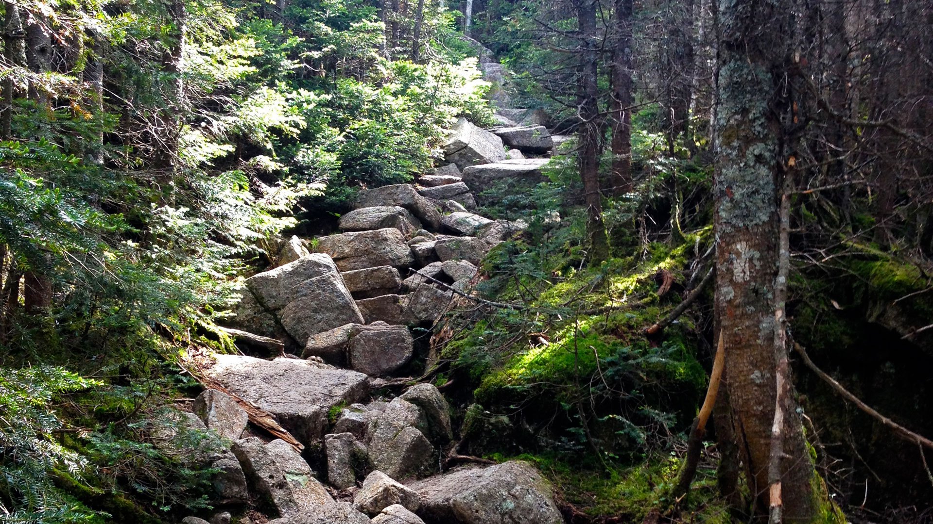
The White Mountains of New Hampshire and southern Maine are generally considered the most difficult section of the Trail. This is due to the rugged terrain, including many steep 1,000+ foot ascents and descents, often long distances between road crossings, and the rocky and root-filled footpath.
The easiest way to get to the Trail is to drive, as many of the access points to the Trail are in remote locations.
However, there are several sections of the A.T. that are accessible via public transportation, and there’s an extensive network of shuttle drivers along the Trail that can transport hikers to most locations along the Trail.
Visit our Transportation & Parking page for more information.
There are parking areas at most road crossings along the Trail and parking areas range from simple dirt lots big enough for only a few cars to large, paved parking areas. Many lots also allow overnight parking. Visit our Transportation & Parking page for more information.
Keep in mind that most A.T. parking lots are not monitored. Never leave valuables in your car and check our Trail Updates page for reports of vandalism. Consider carpooling to reduce congestion in trailhead parking lots.
Yes! Most visitors to the Trail only visit for a day or even just a few hours, called a “day hike.” Most of those visits are concentrated on popular destinations on the A.T. that can be seen on a day hike. If you plan to visit a popular place on the Trail, we encourage the following to help preserve the Trail:
- Always practice Leave No Trace, including being prepared for where you’ll be hiking and packing out all trash and food waste. If you need to go to the bathroom on your hike, be sure to either pack it out or bury it in a 6-8” hole.
- Visit during the week if you can. Popular hikes can become extremely congested on weekends or holidays.
- Plan an alternative hike in case the trailhead is full when you arrive. Do not park along the road if trailhead parking is full and follow instructions on posted signs.
- Come prepared with the 10 Essentials in your pack.
The 14-State Challenge is also a great way to experience the A.T. without hiking the entire Trail.
There are minimal fees to access the Trail itself and only a few sections of the Trail where a permit is required. There is no single Trail-wide permit.
Permits are required in:
- Great Smoky Mountains National Park: must be obtained in advance and costs $8 per person or $40 for an A.T. Hiker permit. There are additional fees for parking a vehicle within the park.
- Shenandoah National Park: must be obtained in advance and costs $9 per person and $6 per permit reservation. There are also additional fees for entering the park.
- Baxter State Park: must be obtained in person before hiking Katahdin and are free. There are fees for entering the park in a vehicle and staying in campgrounds in the park.
Visit our permit page for more information.
In addition to the fee for the permit for Great Smoky Mountains National Park, the only other place where hikers will encounter fees on the Trail itself is in New England, where there are several overnight campsites that have fees ranging from $5 to $20 per person. These fees go back to maintaining the Trai
The rich ecosystems along the Trail are some of the most diverse and untouched in the eastern United States and bears are an important part of what makes those ecosystems so special. In addition to black bears, a plethora of native species — snakes, mice, birds of prey, coyotes, deer, moose, and more — call the A.T. home.
The best way hikers can help protect A.T. wildlife is by properly storing their food in a bear canister overnight, packing out all trash and food scraps, and never leaving food unattended.
Bear Safety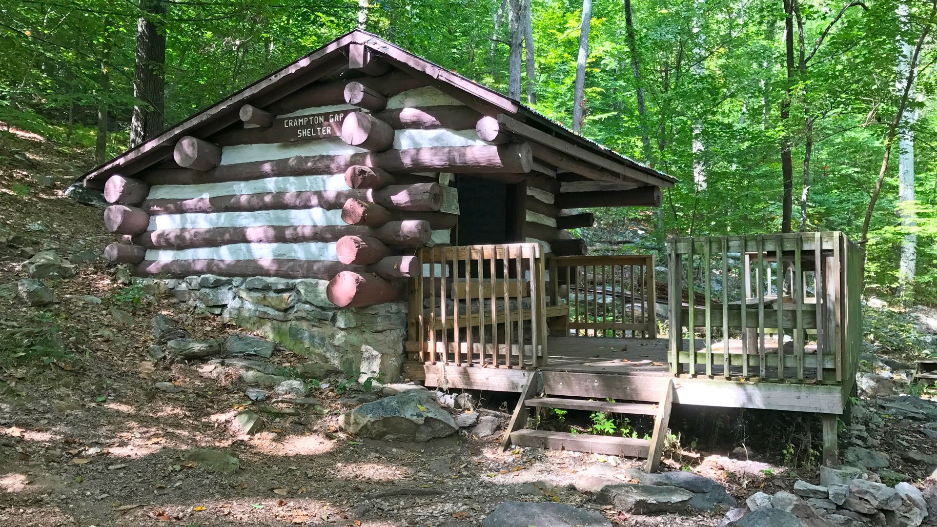
Hiking and Other Activities on the A.T.
Thru-hikers, section hikers, and organized groups (6 or more people traveling together such as camps, college orientation trips, scouts, etc.) should register their hikes on ATCamp, the ATC’s voluntary registration platform. While registration is not required, we highly recommend it.
Registration helps reduce overcrowding on the Trail, which can help prevent damage to the footpath and overnight sites that comes with overuse. Registrants can also opt-in to receive urgent Trail alerts and helpful resources for having a safe and fun visit to the Trail.
Visit ATCamp.org to register your hike today!
Yes! About 3 million people visit at least a portion of the A.T. each year, and a small percentage of those visitors hike the entire Trail in one year — also known as a “thru-hike” — or are working toward completing the entire Trail over several years — also known as “section hiking.”
Thru-hikers complete the entire A.T. in 12 months or fewer (the average thru-hike takes about six months to complete). Section hikers, on the other hand, complete the Trail over two years or more.
If you have completed the A.T., you can apply for a 2,000-miler congratulatory certificate and read about how many people have completed the Trail on our 2,000-miler page.
Yes, much of the Trail winds through the last remaining wilderness of the densely populated east coast, and backpackers may not cross a road for three days or more. So, they camp along the Trail. There are over 250 rustic backcountry shelters along the A.T., most of which are three-side lean-tos. Dispersed camping is also allowed along about half of the A.T.
Backpackers or hikers out for more than a day must carry everything they’ll need on their backs, including a sleeping bag and personal shelter. Learn more about what to carry.
Camping & SheltersAlong with all the gear they will need, hikers must also carry all the food they need.
Along with all the gear they will need, hikers must also carry all the food they need. Day hikers and overnight hikers should always plan on carrying enough food for their trip plus an extra day’s worth of food in case of unexpected delays on the Trail. Long-distance hikers carry enough food to sustain them until they can get to a road crossing and visit a town.
How much food each hiker carries will vary depending on dietary needs, how often each hiker plans to visit towns, and the region of the Trail. For example, the southern and northern ends of the Trail tend to be more remote. In a section of northern Maine called the 100 Mile Wilderness, many hikers will carry seven to ten days’ worth of food. In northern Virginia through southern New England, hikers may only carry two to three days’ worth of food since road crossings are more frequent.
Learn more about hiking staples and how hikers resupply here.
For day hikers, it is often possible to carry in all the water you will need for shorter hikes — always carry at least two liters of water. However, if you are planning an overnight or multiday trip, you should always bring some form of treatment for backcountry water sources. Unless there is an official sign stating that the water is potable, all water along the A.T. should be either chemically treated or filtered before drinking. This includes fresh springs and “piped” water sources at shelters.
While water is generally plentiful along the Trail, some water sources may go dry during drought and others go dry seasonally during summer and fall. Check our Trail Updates page for recent reports of dry water sources and note which water sources are labeled as “seasonal” in guidebooks.
Dogs are allowed on almost the entire Trail. Dogs are not allowed in Great Smoky Mountains National Park (~72 miles), the Trailside Museum and Zoo in Bear Harriman State Park (less than 1 mile), and in Baxter State Park (~14 miles).
The ATC recommends that dogs are kept on a leash at all times, and dogs are required to be on leash for about half of the Trail. Be sure to pack out or bury your dog’s waste as you would your own. Read more about bringing your pup on the Trail here.
While there are safety concerns to consider when visiting the A.T., most dangers on the Trail can be mitigated with proper planning and preparation. This includes the Trail’s most common hazards: weather, injuries (such as falls and lower leg injuries), and ticks. Keep in mind that much of the Trail winds through remote backcountry where assistance may be many hours away. It is the responsibility of each hiker to be informed and prepared for the terrain and conditions they may encounter.
Serious crime on the A.T. is rare. However, the Trail is not immune from the problems that plague society at large. It is important to be prepared to encounter a wide range of different people on the A.T. and take precautions when speaking with strangers. Trust your gut, be polite but wary of new people you meet, and disengage/leave any situation that makes you feel uncomfortable. Always call 911 in an emergency.
Visit our safety page to learn more about the hazards you may face when hiking the Appalachian Trail and how to best prepare for a safe, healthy hike. Always share your hiking plans with someone at home before you head out.
Links to maps and guide sets for the entire A.T. can be found in our ATC Trail Store. Local A.T. maps can also be purchased in person at any ATC visitor center.
The ATC does not maintain any message boards or lists of potential hiking partners. However, you can always reach out to your local A.T. maintaining Club to attend an outing or ask if they know of anyone interested in hiking with you.
Other sources like social media groups, hiking forums, and A.T. websites may be helpful. Always be sure to properly vet any hiking partners.
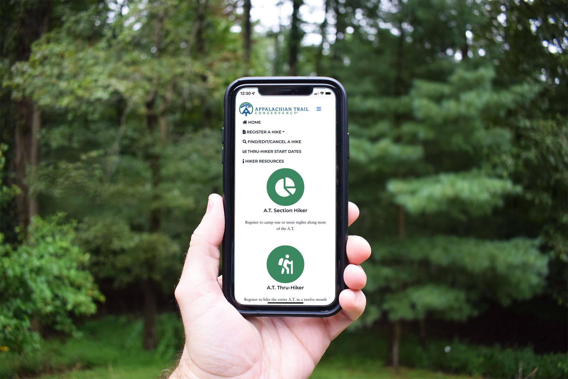
Registering Your Trip on ATCamp.org
Yes! See our ATCamp Step-by-Step Registration Instructions for detailed help with registering. If you still have trouble, please contact us.
ATCamp is a voluntary registration platform and registration is not required. However, we strongly encourage registration. ATCamp is a visitor use management tool that helps reduce overcrowding and subsequent resource damage on the A.T. and provides the ATC with data on the overall use of the Trail. This information helps the ATC, volunteer Clubs, and agency partners best manage the Trail and Trail resources.
Registered hikers can also opt-in to receive urgent Trail alerts and other information to help them plan a safe and successful visit to the A.T.
Overnight and thru-hikers starting at Amicalola Falls State Park are required by the park to register on-site for safety reasons in case of emergency. Registration on ATCamp will expedite on-site registration at AFSP. Have your ATCamp registration number readily available to take advantage of this.
No, ATCamp is a voluntary registration system, not a reservation system. Except in the Great Smoky Mountains National Park (GRSM), all A.T. shelters are first come, first served. In GRSM, you will need to apply for a required permit. ATCamp is not a reservation system for Appalachian Mountain Club White Mountain huts.
Organized groups are asked to not stay in shelters and instead camp nearby in established sites. Learn more about Leave No Trace for groups on the A.T.
No, ATCamp registration does not replace the required permits for Great Smoky Mountains National Park (GRSM), Shenandoah National Park, or Baxter State Park. Please note that there is no single Trailwide permit for the A.T.
Permits & FeesYes, if your plans change, please edit your registration to reflect your new start date/itinerary. Be sure to check that your new preferred start date and campsites are not already at capacity.
You can change or cancel your registration by clicking on the “Edit” button in the My Registrations section of your ATCamp account.
If you are changing your start date, please be sure to check that your new preferred start date and campsites are not already at capacity. If your new preferred start date and itinerary are at capacity, please choose a different start date/itinerary to help prevent damage to the Trail.
The capacity thresholds or quotas for overnight sites are based on available campsites and are set at levels that ensure visitor use will not further degrade A.T. resources. If your desired start date is at capacity, we highly encourage you to choose a different start date.
No, your registration number will stay the same if you edit your registration.
The ATC does not mail current year hangtags. One hang tag is allotted per person. Thru-hikers and section hikers intending to complete the entire Trail can pick up hang tags at the following locations:
- Amicalola Falls State Park Visitor Center in Dawsonville, GA
- Damascus Trail Center in Damascus, VA
- The ATC Harpers Ferry Visitor Center in Harpers Ferry, WV
- The A.T. Visitor Center in Monson, ME (open June to October)
Please note that A.T. hangtags are typically available starting in early February each year. Northbound thru-hikers starting in January can get their hangtags at the Damascus Trail Center when they reach Virginia.
If there are leftover hangtags at the end of the year, they are made available for purchase through our ATC Trail Store.
We use ATCamp registration numbers from the previous year to determine the number of hang tags we order. Registration on ATCamp helps ensure that ATC orders enough hang tags for all thru- and section hikers.
You can turn off ATCamp alerts by updating that setting in your ATCamp account under Trail Alert Settings.
Learn more about the ATC and the A.T.