The A.T. at a Glance
2,197.9
total miles of the A.T.
464,500
elevation gain/loss (ft)
14
states the A.T. traverses
16.9M
annual recreation visits
About the Appalachian Trail
The Appalachian National Scenic Trail, better known as the Appalachian Trail or A.T., is the longest hiking-only footpath in the world.
The Trail travels along the crests and valleys of the Appalachian Mountain Range from its southern terminus at Springer Mountain in Georgia, to the northern terminus at Katahdin in Maine’s Baxter State Park.
In 2025, the A.T. saw 16.9 million recreation visits, and more than 3,000 people attempt to “thru-hike” the entire footpath in a single year. People from across the globe are drawn to the A.T. for a variety of reasons, such as reconnecting with nature, escaping the stress of city life, meeting new people or deepening old friendships, or experiencing a simpler life.
Completed in 1937, the A.T. is a unit of the National Park System. It is managed under a unique partnership between the public and private sectors led by the Appalachian Trail Conservancy.

These resources are made possible thanks to member support.
Right now, you’ll receive the 2027 ATC calendar with your gift of $75 or a monthly gift! Support the Trail, plus get this limited-edition calendar today.
Explore by State
There is a stunning diversity of terrain, features, and landscapes along the 14 states the A.T. passes through. Learn cool facts, significant stats, recommended day hikes, and more for each state.
Explore by State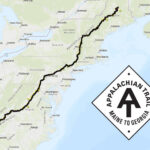
Plan Your Hike


Fun facts about the Appalachian Trail
- The length of the Trail changes slightly each year due to footpath relocations and improved measurement techniques.
- It takes roughly 5 million steps to hike the entire A.T. — whether that is over a series of section hikes or one “thru-hike” in a single year.
- Thousands of volunteers contribute hundreds of thousands of hours to maintain the A.T. every year.
- More than 250 three-sided shelters exist along the Trail.
- Virginia is home to the most miles of the Trail (557), while West Virginia is home to the least (2.4).
- Maryland and West Virginia are the easiest states to hike; New Hampshire and Maine are the hardest.
- The total elevation gain of hiking the entire A.T. is equivalent to climbing Mt. Everest 16 times.
- The A.T. is home to an impressive diversity of plants and animals. Some animals you may see include black bears, moose, porcupines, snakes, woodpeckers, and salamanders. Some plants you may encounter include jack-in-the-pulpit, skunk cabbage, and flame azalea.
- The A.T. passes through six National Park Service units, including Great Smoky Mountains National Park, Blue Ridge Parkway, Shenandoah National Park, Harpers Ferry National Historical Park, Chesapeake & Ohio Canal National Historical Park, and Delaware Water Gap National Recreation Area.
- The A.T. also traverses eight National Forests — Chattahoochee, Cherokee, Nantahala, Pisgah, Jefferson, George Washington, Green Mountain, and White Mountain National Forests — and two National Wildlife Refuges — Wallkill River and Cherry Valley National Wildlife Refuges.
Explore the A.T. Interactive Map
Interactive Map
Fun facts about A.T. Hikers
- The A.T. has hundreds of access points and is within a few hours’ drive of millions of Americans, making it a popular destination for day-hikers.
- “Thru-hikers” walk the entire Trail over 12 months or less. “Section-hikers” complete the entire Trail together over two years or more. “Flip-floppers” thru-hike the entire trail in discontinuous sections to avoid crowds or extremes in weather, or to start on easier terrain.
- One in three who attempt a thru-hike successfully completes the journey. See the latest thru-hiking statistics.
- Most thru-hikers walk north, starting in Georgia in spring and finishing in Maine in fall, taking an average of 6 months.
- Hikers usually adopt “trail names” while hiking the Trail. They are often descriptive or humorous. Examples are “Eternal Optimist,” “Thunder Chicken,” and “Crumb-snatcher”.
About the Appalachian Trail Conservancy
The mission of the Appalachian Trail Conservancy (ATC) is to protect, manage, and advocate for the Appalachian National Scenic Trail.
Our Values & Mission