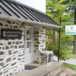
Welcome to the Monson Visitor Center
We help long-distance and day hikers plan safe and enjoyable adventures on the Appalachian Trail and other trails in the 100 Mile Wilderness and Moosehead Lake regions.
Address:
6 Tenney Hill
Monson, ME 04464
413.200.0313
Hours of Operation
The Monson A.T. Visitor Center is open for the 2026 season from May 30 to October 12.
The center will remain open for the Juneteenth holiday on Friday, June 19, and through the holiday weekend.
- Monday: 8:00 – 11:00 a.m. and 1:00 – 5:00 p.m.
- Tuesday: staffed as available; please check ahead
- Wednesday: staffed as available; please check ahead
- Thursday: 8:00 – 11:00 a.m. and 1:00 – 5:00 p.m.
- Friday: 8:00 – 11:00 a.m. and 1:00 – 5:00 p.m.
- Saturday: 8:00 – 11:00 a.m. and 1:00 – 5:00 p.m.
- Sunday: 10:30 a.m. – 5:00 p.m.
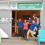
Take a Tour of the Center
Exhibits
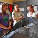
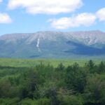
A scale model of Katahdin, Maine’s highest mountain and the northern terminus of the Appalachian Trail, shows the many hiking routes the mountain offers. Visitors will also find a variety of exhibits and artifacts related to the history of the A.T., the town of Monson, and the Maine Woods.
Volunteer at the Monson Visitor Center
If you are interested in volunteering at the Monson Visitor Center, please stop in or click the link below to learn more and apply.
Volunteer
Services
Assistance to northbound A.T. hikers
Planning for permits, camping, and hiking routes in Baxter State Park; safety alerts for the Hundred Mile Wilderness; planning for post-hike lodging and transportation.
Assistance to southbound A.T. hikers
Thru-hike registration, with hang tags available for registered hikers; information about the Kennebec Ferry; planning for southern Maine and New Hampshire; trail safety updates and education.
Assistance to day hikers
Maps, guides, and help with selecting appropriate hikes along the A.T. and other trails in the Hundred Mile Wilderness and Moosehead Lake regions.
Assistance to tourists
Maps, guides, and information about activities in Monson, Greenville, the Hundred Mile Wilderness and Moosehead Lake regions. If we don’t know the answer to your question, we’ll help you find it!
Other services
A.T. passport stamp, WiFi, phone charging. We allow hikers who are unable to access cell service to make brief calls using the Visitor Center phone.
Store
We sell maps and guidebooks.
Links to Local Hiking Information
Monson Day Hikes
Paper copies of both the descriptions and map are available at our visitor center.
Mike Rudd
Moosehead Lake & Hundred Mile Wilderness Regions
- Hiking Guide to the Moosehead Lake Region compiled by Destination Moosehead Lake, the local Chamber of Commerce
- Moosehead Pinnacle Pursuit, a collection of six hikes in the Moosehead Lake region. One of these hikes, up Whitecap Mountain, follows the Appalachian Trail (please note that access to the Whitecap trailhead requires a vehicle with high clearance).
- Borestone Mountain Audubon Sanctuary, a popular hike near Monson (it is also one of the six Moosehead Pinnacle Pursuit hikes).
- Appalachian Mountain Club’s Maine Woods Initiative
- Map of trails accessed via the Katahdin Iron Works Road
- Map of trails in the Roach Ponds area
- Gulf Hagas information and area map. Gulf Hagas is a slate gorge with a series of spectacular waterfalls and can be accessed via an official A.T. side trail.

Steve Rincavage
Katahdin Region
- Baxter State Park, home to Katahdin, the northern terminus of the A.T.
- Katahdin Woods and Waters National Monument information can be found through the National Park Service and Friends of Katahdin Woods and Waters. This national monument, located to the east of Baxter State Park, was established in 2016.

James Davis
Northward from the Katahdin Region
- International Appalachian Trail (Maine Section). The Maine segment of the I.A.T. begins in the Katahdin Woods and Waters National Monument east of Baxter State Park and extends northward to the Canadian border crossing near Fort Fairfield.
Additional Information
Parking
Ample on-street parking is available for the Visitor Center and for shops and restaurants in Monson. For the A.T.: The A.T. crosses Route 6/15 approximately 3.6 miles north of the Visitor Center. There is a parking area on the east side of the road (the right side of the road as you head north from Monson).