New Hampshire – Bridge Closure – Great Gulf, Updated 7/24/25
New Hampshire
closure
|hiking-safety
|Alert
07/24/2025
Update: The AMC is providing thru-hikers with free shuttle service between the 19 Mile Brook Trailhead and Pinkham Notch Visitor Center due to the bridge closure. See the 2025 AMC Hiker Shuttle Schedule for times.
The Madison Gulf Suspension Bridge where the A.T. crosses the West Branch of the Peabody River remains closed due to structural failure (NOBO mile 1,873.8; also called the Great Gulf Suspension Bridge). The bridge is not safe to use and is officially closed by the U.S. Forest Service. Hikers may be cited for using the bridge.
A.T. hikers have two options to continue their journey. All these options are acceptable for our 2,000-miler program:
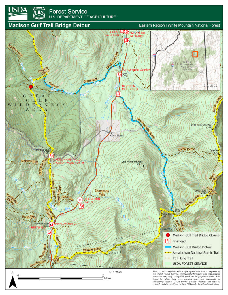
Option A; Official USFS Detour: Great Gulf to Carter Notch Hut. The detour is now marked with temporary white plastic blazes. See map below.
NOBO (northbound) Directions:
- From the Osgood Campsite, take the Osgood Trail where it veers left away from the A.T. and follow it for 0.8 mi to the junction with the Great Gulf Trail. Follow the Great Gulf Trail for another 1.5 miles to Route 16.
- When you reach the Great Gulf Trail parking lot and trailhead, walk the access road a short distance out to Route 16. Turn right on Route 16 heading south and walk along the shoulder for 0.5 mi. Be very careful when walking along the road. Route 16 is a busy route with fast moving cars.
- Alternative: Arrange a ride or take the free AMC Hiker Shuttle from the Nineteen Mile Brook Trail to Pinkham Notch, and then continue on the A.T. northbound from Pinkham Notch.
- After 0.5 mi, you’ll see the Nineteen Mile Brook Trailhead on the left side of the road. It is a large dirt lot with a kiosk at the far end.
- Follow the Nineteen Mile Brook Trail for 3.6 miles as it winds up to the ridge and back to the A.T. Turn left on the A.T. and continue northbound.
SOBO (southbound) Directions:
- Just past the Carter Lakes you’ll come to the signed junction of the A.T. and the Nineteen Mile Brook Trail. Turn right onto the Nineteen Mile Brook Trail and follow it 3.6 miles to Route 16.
- Alternative: Continue on the A.T. southbound down to Pinkham Notch. From Pinkham Notch, arrange a ride down to the Great Gulf Trailhead or take the free AMC Hiker Shuttle to the 19 Mile Brook Trailhead and walk the short distance to the Great Gulf Trailhead from there.
- At Route 16, turn right and follow the road for 0.5 mi to the Great Gulf Trailhead. The trailhead access road is on the left side road and has a large White Mountain National Forest sign for the Great Gulf Wilderness at the entrance.
- At the far end of the large dirt parking lot, follow the Great Gulf Trail for 1.5 miles to the junction with the Osgood Trail.
- Veer right into the Osgood Trail and follow it for 0.8 mi to Osgood campsite and the A.T. When you reach the A.T., turn right to continue southbound.
Option B: Ford the river
The West Branch of the Peabody River is a significant crossing along the A.T. It is a dangerous crossing in all but dry conditions when the river’s flow is low and even then, it can be difficult. The riverbed is mostly large boulders with deep, swift moving pools of water around them (there is a photo of the riverbed at the bottom of this alert). Only hikers with experience fording rivers should attempt this option and only during dry weather. Learn about how to safely ford a river by visiting our River & Stream Crossings page.
SOBOs: you will not have a good option to detour around the river once you reach it. It is extremely important to exercise good judgement and be realistic about your ability to ford the river. We strongly recommend taking the detour.
For more information about the bridge closure, visit the White Mountain National Forest website.

Photo courtesy of the AMC.

