In Defense of the View

Oct 31, 2019

Oct 31, 2019
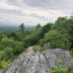
When the Appalachian Trail isn’t just a ‘long green tunnel’, it is rewarding visitors with sensations of awe, as they marvel at the perspective they have from the height of land. Perhaps it’s being out of breath from the exertion of the hike, or the magnificence of seeing the world laid out before them.
 However, is it possible to protect these resources if we can’t place value on them? That’s not a rhetorical question. Sure, places and views carry emotional value, but how do we know which views are of greatest quality, carry importance and are worthy of protection unless we catalog them?
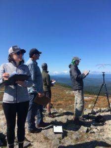
Rather than taking views for granted until they are under threat, the Appalachian Trail Conservancy, NPS, Nantahala Hiking Club, Roanoke Appalachian Trail Club, Mountain Club of Maryland, and Maine Appalachian Trail Club worked throughout 2019 to pilot anapproach to tracking the qualities of scenic vistas as part of a visual resource inventory that provides an objective framework for evaluating the places that make the A.T. special. During the season, teams conducted field assessments at 70 viewpoints.
The inventory looks at the character (natural, rural, industrial, etc.) and aesthetics of a view, including lines, forms, shapes, colors, textures, and balance. Coupled with research on the use of the place and its value to the visitor experience, sites are assigned a value. The pilot project is wrapping up; once complete, the information will live in a NPS database, and may make its way into club local management plans that describe how the club cares for these places. Moreover, the catalog ensures that we have ways to communicate where the highest value places are so that we can account for them, and protect them by working for appropriate use and development in a given viewshed.
The process follows the Visual Resource Assessment process designed by the NPS Air Resources Division and Argonne National Lab. “It is volunteer friendly, intuitive and flexible for a diversity of landscapes and park types,” says ATC’s Director of Science and Stewardship Marian Orlousky. She said that as part of the pilot, there were participants from land management partners, visitors’ bureaus, academia, other non-profit entities with shared interest, and many volunteers from clubs. Because the protocols can be implemented by a wide variety of people, it also lends the potential to engage new volunteers within clubs who ‘just hike,’ or other partners in a geographic area, like A.T. Communities.
Clubs or A.T. Communities with an interest in undertaking a visual resource inventory of their area, utilizing the NPS collection method, should contact their regional office with interest and a request for training. While project expansion depends on resources to host trainings and provide staff support for the initiative, it is helpful to know where future opportunities may prove most fruitful. That said, the possibility exists to prioritize the visual resource inventory project in New Jersey and Pennsylvania next where development pressures and a narrow corridor of protected lands make this kind of project all the more urgent. ATC will be reaching out to club leadership in those areas soon to identify and coordinate interest.
Give today to get your limited-edition 2027 calendar featuring breathtaking scenes from the Trail.
Reserve my calendar