How Hikers Helped Route the A.T. to McAfee Knob

Aug 14, 2025

Aug 14, 2025

McAfee Knob is one of the most photographed spots on the Appalachian Trail (A.T.). Its popularity today is supported by infrastructure like a new pedestrian footbridge and a shuttle system, which improve access while reducing impacts on this iconic destination. However, it was almost bypassed when desktop planners laid out the Trail in Virginia. Myron Avery, the A.T.’s master builder and organizer, initially followed the advice of local county extension agent Shirley Cole and drafted a route that followed the crest of the Blue Ridge Mountains for 200 miles. This path would have been about 15 miles east of McAfee Knob, on the other side of Roanoke. Local hikers who formed the Roanoke Appalachian Trail Club (RATC) convinced him to change his mind by 1933. The story has been buried in old files for decades and is told here for the first time since the 1950s.
The Blue Ridge route had been cleared, measured and partially marked when Avery and volunteers from the Potomac Appalachian Trail Club (PATC) came to the Roanoke area in October 1932 to drum up interest in the formation of a local trail club. Avery wanted trail builders, but the people who showed up were members of three local hiking clubs. One group was at Roanoke College and another at Hollins College. Both were founded in 1842 and located close to McAfee Knob and Tinker Cliffs. Roanoke had been all-male until 1930, and Hollins was all-female. The third club was “The Nomads,” a co-ed group of local U.S. Post Office workers and their friends who hiked on Sundays, their only day off.
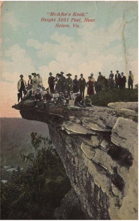
An early 20th-century postcard featuring McAfee Knob, decades before it became part of the official A.T. route. Image courtesy of the RATC Archives.
On November 13, 1932, members of all three groups went for a walk in Carvins Cove, below McAfee Knob and Tinker Cliffs, followed by supper at the home of Donald Gates, an economics professor at Roanoke College. Then eight women and nine men founded the Roanoke Appalachian Trail Club. They believed their main challenge was “the re-routing of the trail from East of Roanoke. . . to what club members felt was the more desirable route North and West of the city.”1 In a 1933 report, RATC trail committee chair David Dick noted that the initial Blue Ridge route “had been measured but not very definitely marked, and it would in a good many instances require a complete relocation. Considering this, and also that there are few points of outstanding interest on the southern route [emphasis added], it was suggested and approved by the club to locate The trail along the more interesting route north of Roanoke.”2
RATC founders were not the first generation to enjoy having their picture taken on McAfee Knob. Fuller Robinson, a 93-year-old Roanoke dentist (who still sees patients today) climbed it as a young man. He recently told me that his own father, also a local dentist, recalled crowds so large on McAfee Knob in the early 20th century that it was hard to find a place to park his horse and buggy on the dirt road that ran almost to the top. An old postcard shows a well-dressed crowd enjoying McAfee.

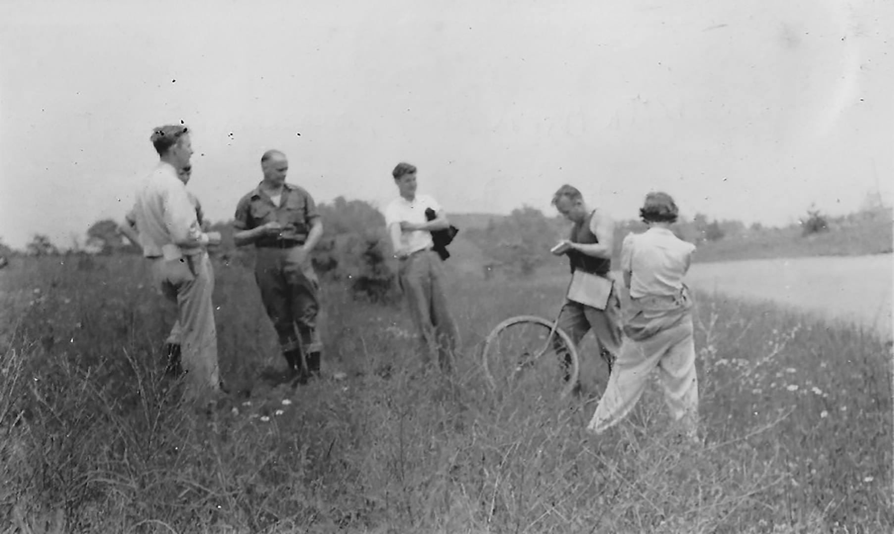
RATC leader David Dick (left) traverses Tinker Cliffs with fellow hiker John McGinnis in 1932. Image courtesy of the RATC Archives.
Once he had seen Tinker Cliffs and McAfee Knob, Avery endorsed the new route and personally supervised its construction during the spring and summer of 1933. He would take a train from Washington, DC, to the Roanoke area on Friday night, often staying at the Meadow View Inn in Daleville. Few RATC members had cars, and most arrived by bus or train to spend the weekend marking, measuring and mapping the new trail. Club leader David Dick later described Avery as “very business-like” and recalled an RATC volunteer lifting Avery’s famous measuring wheel across a stream. “Mr. Avery made him take it back and run it through the water so the measurement would be exact.”3
Myron Avery (second from right) measures a section of the A.T. near Bent Mountain, Virginia (1940). Image courtesy of the RATC Archives.
Avery oversaw the production of maps and a guidebook for the A.T. in Virginia. The first one was printed by the PATC in 1931, when the Trail east of Roanoke was mostly a road walk through the town of Vinton, below the Blue Ridge. The second version would have been on the Blue Ridge but was never fully completed. RATC volunteers and Avery completed and mapped the third version around Roanoke in 1933, and the PATC published a new guidebook in 1934 that included three maps of Virginia south of the PATC section:4
Dick’s map was also printed and sold separately by both the PATC and RATC, as he noted in his 1933 report to the RATC board. He also asked for reimbursement of his expenses:
At the request of Mr. Avery I made a map of the section of the trail from Lee Highway [US 11] near Cloverdale to New River [near Galax], for the Potomac Appalachian Trail Club’s new Guidebook. The Potomac club has had 900 copies printed at a cost of $30.00 from which they sent us about 300 copies. I have incurred an expense of $2.50 in making this map which I feel should be borne by our club. Mr. Avery suggested that these copies sold at 25¢ would bring in considerable revenue for paint, markers, etc.

This map, produced by RATC leader David Dick in 1933, shows the route of the A.T. as it traverses McAfee Knob and Tinker Cliffs. Image courtesy of the RATC Archives.
RATC lost track of this map for decades. I rediscovered it in 2020. Neither the 1933 David Dick map nor its routing near McAfee Knob nor the role of RATC volunteers has ever been noted in any published sources I have seen. The 900 PATC copies of the map seem to have disappeared. Fortunately, I found three copies in the RATC archives in 2020, along with a February 1939 clipping from the Roanoke Times, featuring the same map and a detailed discussion of RATC and its section of the Trail.
You never know what you will find in the basement or the attic! In this case, I found the history of how the A.T. was officially routed to one of its most iconic and beautiful sections, providing future generations of visitors an opportunity to experience (and help conserve) the natural beauty of McAfee Knob and Tinker Cliffs.
1 1945 RATC History, RATC Archives
2 RATC Archives
3 1945 RATC History, RATC Archives
4 I am deeply indebted to independent researcher James McNeely for information of the early guidebooks. His website is a treasure trove of information about the early A.T., including the route traveled by Earl Shaeffer.
 Diana Christopulos lives in Salem, Virginia, and is a retired owner of an international management consulting business. She is a life member and supporter of the ATC, and was elected the Cox Conserves National Hero in 2019, donating the $60,000 prize to the ATC. An avid hiker, Diana also finished a complete section hike of the A.T. in 2008. She is a former President of the Roanoke Appalachian Trail Club and its current Archivist, having negotiated inclusion of its extensive archives as part of the Permanent Collections of Virginia Tech University. She received her degrees in American History from Cornell University (bachelor’s) and Binghamton University (master’s and doctorate).
Give today to get your limited-edition 2027 calendar featuring breathtaking scenes from the Trail.
Reserve my calendar