Danica Perhacs
October 2013
Danica Perhacs has volunteered for the ATC land protection program since 2011. She began by organizing files and checking deed descriptions and maps for ATC-owned properties that help to buffer and protect the Trail from development and encroachments.
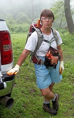
Monitoring those properties means knowing where the boundaries are. Over the past year, Danica has helped to find, clear, and mark the boundary lines on ATC properties in nine Trail states, working with her sister Carlen Emanuel, ATC’s land protection manager.
Danica says preparation is key—researching deeds and easements, examining survey maps, determining access to parcels, contacting adjacent landowners as needed, making a work plan, setting up a base camp. Loppers, paint, flagging tape, signs, nails, other tools, and protective gear need to be packed and ready to go.
Once in the field, more challenges arise: most properties have not had GPS coordinates taken,
some have no surveys. Deed descriptions may describe reference trees that no longer stand, or stone walls and rock formations that have crumbled or are difficult to distinguish from others. Safety is always a priority, requiring being careful on difficult terrain and alert for changing weather, biting insects, poison ivy, and more.
Danica lives in Florida, where she and her husband have a canvas shop. She grew up spending much of her time outdoors and says, “I like to have my hands in the dirt and my feet in the woods.” Embracing the challenges of volunteering with the ATC lands program, Danica says, “There is a sense of accomplishment and gratification at being able to look back at a cleared line and know that someone will have an easier time in the future.”