Why Katahdin is Unlike Any Other Mountain on the A.T.

Nov 19, 2026

Nov 19, 2026
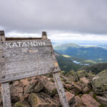
Katahdin has been challenging Appalachian Trail (A.T.) hikers for decades. Its windswept peak, home to the northern terminus of the Trail, is perched two trail miles above treeline and requires a tremendous effort to reach. Many consider it to be the hardest climb on the entire A.T.
In this blog, we share what sets Katahdin apart from other peaks on the Trail, and how to prepare for the unique difficulties of the climb.
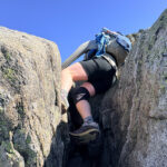
Katahdin is the longest sustained ascent on the Trail. Located in Baxter State Park, the A.T. follows the Hunt Trail from Katahdin Stream Campground for 5.2 miles to the summit at Baxter Peak. Hikers climb over 4,000 feet along the way, meaning that the route is incredibly steep and even technical in many places—requiring hikers to use their hands for balance or even use basic climbing moves to traverse the path.
Leah Beck, the ATC’s Regional Manager for Maine, shares: “You’re using your full body to climb this mountain, and a lot of it is hand-over-hand scrambling. It is a climb, not a hike—the difficulty can’t be overstated.” Shorter hikers in particular may find some of the boulders challenging.
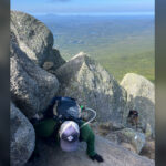
Dave “Poptart” Tarasevich, the Visitor Services Lead at the ATC’s Harpers Ferry Visitor Center, points out that if there’s no easy way up, there’s also no easy way down. “The middle two miles of the Hunt Trail are relentless. It’s easy to run out of gas quickly, which makes going downhill on Katahdin just as exhausting as going up.”
It’s critical to save enough energy for the difficult scramble down. The park reminds visitors on signs and brochures that “your destination is not the summit, but your safe return to the trailhead.”
Many of the other hard climbs on the A.T. have trees or topography that provide relative protection from the elements. The upper half of the Hunt Trail, though, is above treeline and follows the spine of the ridge, meaning you have to contend with the elements and extreme terrain together. Many sections have sheer drops on either side of the Trail, and the sense of scale can be dizzying, literally. Those with a fear of heights or vertigo may struggle and should mentally prepare for the steep pitches and lack of cover.
Any adverse weather will heighten those feelings and make it more difficult to find a path forward. “I’ve turned around twice,” Beck shares. “One time I had to turn around on Abol Trail when I was about to reach the Tablelands (a vast alpine plateau below the summit), but it started to sleet. The other time I saw the weather at the summit and decided to head back down.”
James Robertson
The size of Katahdin can put hikers at a disadvantage, too, by blocking any view of incoming weather. “Often you don’t know bad weather’s coming until you’re on the Tablelands,” Tarasevich shares. “At that point, it’s hard for hikers to turn around.”
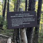
Beck emphasizes the remote nature of Baxter State Park. “You’ll realize when you’re driving or hiking into the park how remote this place is. The choices you make from then on out should be made with that in mind.” Katahdin pushes hikers even further into the wild. About a mile into the Hunt Trail, the park has a sign that warns visitors they are entering “Maine’s largest wilderness.” As you break out of treeline and continue the ascent, you begin to understand what this means.
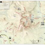
By the time you reach Hunt Spur, a short flat spot about halfway up the ridge, the world below is already far away, and there’s still much more to climb. There are no side trails that allow you to duck for cover quickly in bad weather, and no services or structures on the mountain. You won’t reach the Abol Trail, the only alternative way down the mountain on the southern side, until the Tablelands. Even then, the Abol Trail doesn’t reach treeline for almost a mile.
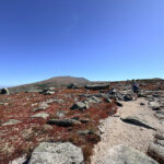
The Hunt Trail is relatively easy to follow on the Tablelands until you start the final ascent just past Thoreau Springs. The Trail turns from a pebbly footpath lined by string and rocks (to protect the fragile alpine vegetation) to small boulders. The final half mile or so is all rock hopping. Tarasevich warns that at this point it can be hard to distinguish exactly what rocks are on the Trail and which aren’t. This can make it very hard to find your way if fog, snow, rain, or wind obscures your vision.
Despite these challenges, thousands of people successfully climb Katahdin each year and make it back down safely. You can, too, by arriving prepared.
The first step in preparing for a Katahdin climb is to prepare to visit Baxter State Park. The park has a unique management model that values wilderness over recreation, and reservations are required for most visitors. Free permits are required for A.T. hikers to summit Katahdin.
Beck recommends that hikers research “what route you’re going to take knowing that not all trails are conducive to going down.” Some A.T. hikers go up Hunt and down Abol, since Abol Trail may be slightly less difficult to descend. Whether you decide to stick to the Hunt Trail or make a loop with the Abol Trail, as an A.T. hiker plan to stay on those two trails. Taking any other trail down puts you on the wrong side of the mountain, a full hour drive from Katahdin Stream Campground.
Learn more in our Hiker’s Guide to Katahdin and Baxter State Park. NOBO (northbound) A.T. thru-hikers should also be ready to Finish Well when they reach the park.
“The main thing I tell people is to have a turnaround time and stick to it,” Tarasevich shares. Beck agrees, “Turnaround time is critical for this mountain. If you’re not at the summit halfway through your day, you need to turn around.”
Turning around just shy of your goal—especially when that goal is Baxter Peak—is much easier said than done. But it’s easier when you practice ahead of time! It may sound silly, but picturing yourself turning around makes it easier to do in the moment. Decide what time you’ll turn around, and what conditions would make you turn around (lightning, running out of food/water, injury, etc.). Stick to these predetermined turn-around points no matter what.
Bring everything you need to spend the entire day on the mountain. Katahdin can take even fit thru-hikers eight hours or more, and most people need a full 10-12 hours to complete the hike. Beck advises that “Finding the right amount of gear is important,” especially for SOBOs (southbounders). “You need extra snacks, extra water, the 10 Essentials, and the appropriate gear for being above treeline, but you don’t want to take up your fully loaded pack that’s got your resupply for the 100 Mile Wilderness.”
Instead, backpackers (SOBOs and NOBOs alike) should take advantage of the loaner day packs available at the Katahdin Stream Ranger Station.
Learn more about the 10 Essentials and what to carry on the A.T.
Having an extra day or two built into your schedule gives you the best chance to be able to summit in good weather. Not only does this greatly improve safety—remember, there is no easy way back to the shelter of treeline if bad weather blows in—but waiting for good weather is worth it. The views on Katahdin are some of the best on the entire Trail.
The park uses a rating system for conditions on the mountain, from Class 1 (green; Excellent) to Class 4 (red; Hazardous). Talk with the park rangers before summiting and check the rating for that day, which is posted at all trailheads each morning. You can also check the National Weather Service’s recreation point forecast for Katahdin ahead of time (there is no cell service in the park until you’re already on the mountain).
Learn more about weather hazards and how to stay safe.
For the most part, NOBO thru-hikers will be physically prepared for the climb by the time they reach Abol Bridge. Other hikers should train for Katahdin. If you don’t already do a lot of hiking, bouldering, trail running, or similar activities, it’s a good idea to start a workout routine several months in advance of your planned summit date.
All Katahdin trails are physically demanding and require a high level of fitness. Building your cardiovascular endurance and leg strength is critical. Good upper body and core strength will help with the boulder scrambles, and strong hip and thigh muscles will help save your knees on the way down.
Planning to climb Katahdin in retirement? Read our essential tips for senior hikers on how to prepare for the A.T.
“Northbound A.T. thru-hikers are extremely fit, but most friends and family will be challenged on Katahdin.” Tarasevich advises as he recalls countless stories from hikers about their plan to summit with loved ones not working out as hoped. “It’s a long drive back from Maine. Do you really want to sit in the car for hours with someone you abandoned on the mountain?” he quips.
To make the experience more enjoyable for everyone, consider meeting friends and family at the base of the mountain rather than inviting them on the climb. We have more tips for how to share the end of your journey with your people in our Friends & Family Guide to Baxter State Park.
Whether at the beginning of a southbound thru-hike, the end of a months-long northbound A.T. journey, or somewhere in between, reaching the Katahdin summit sign is an indelible moment. By properly preparing for your climb, you can not only reach the sign yourself but, most importantly, make it back down the mountain safely.
Dave “Poptart” Tarasevich has worked at the ATC’s Harpers Ferry Visitor Center for more than 15 years educating hikers about the Trail. Before joining ATC, he spent six seasons with the Maine Appalachian Trail Club (MATC) as an A.T. Ridgerunner. Four of those seasons were spent at Abol Bridge, the entrance to Baxter State Park on the A.T., helping hikers plan their climb of Katahdin. He thru-hiked the A.T. in 2002.
Leah Beck joined the ATC in 2023 but has been connected to the A.T. since 2015 when she served with the Maine Conservation Corps trail crew. Her master’s thesis from the University of Maine focused on visitor use management on the A.T. in Baxter State Park and A.T. hikers’ experiences on Katahdin. She’s climbed the mountain 10 times over the course of her career and has thru-hiked the Pacific Crest Trail.
Featured photo by Benjamin Williamson.