Information on how to navigate Baxter State Park’s rules and reservation system as an Appalachian Trail (A.T.) hiker so you can get into the park and summit Katahdin, including information on transportation to and from the park.
Katahdin, the A.T.’s Northern Terminus
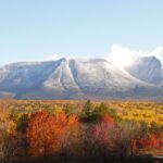
Katahdin, Maine’s tallest mountain and the northern terminus of the Appalachian Trail, lies in Baxter State Park.
Baxter is a unique place along the Trail, managed for “wilderness first, recreation second.” Katahdin has been a sacred place for the Penobscot people, who are part of the Wabanaki Confederacy (People of the Dawnland), for thousands of years.
Help protect this special place and be a good ambassador for the A.T. by following the park’s rules.
Kim Pak

Picking Up or Meeting Your Hiker in the Park?
Friends and family who plan to meet, pick up, or hike Katahdin with their hiker should visit our Friends & Family Guide to Baxter.
Planning Your Katahdin Summit
Step 1: Orient Yourself
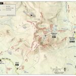
Look at a map of the park to help orient you to the information below.
Millinocket is the closest town to Baxter State Park, about a half hour’s drive southeast of the Togue Pond Gate (the park’s main entrance). Monson, at the southern end of the 100 Mile Wilderness off Route 15, is a popular stop for long-distance hikers and home to the ATC’s Monson A.T. Visitor Center. The 100 Mile Wilderness is the section of the A.T. between Monson and Baxter State Park. It gets its name because no public roads cross the Trail for those 100 miles.
River & Stream Safety
The 100 Mile Wilderness has several unbridged river crossings. Learn how to ford a river and when to turnaround on our River & Stream Crossings page.
Park Entrances
- Most northbound A.T. hikers will enter the park at the kiosk on the Trail just north of Abol Bridge and the Golden Road. Generally, everyone else will enter the park via the Togue Pond Gate.
Inside the Park
- The main campground associated with the A.T. in the park is called Katahdin Stream Campground. The A.T. goes through the campground.
- The A.T. up Katahdin is called the Hunt Trail in the park. It is 5.2 miles from Katahdin Stream Campground to the summit of the mountain and over 4,000 feet of elevation gain.
The “Abols”
Several places along the A.T. in this area have the name Abol and are commonly confused with one another.
- Abol Bridge is outside of the park. It is a road bridge where the Golden Road crosses the West Branch of the Penobscot River. The A.T. follows this road bridge.
- Abol Bridge Campground and Store is also outside of the park. It is a private business along the Golden Road at Abol Bridge. They have ice cream, small resupply, showers, and camping for a fee. There is no internet, phone, or cell reception at the store.
- Abol Pines is also outside of the park. It is a state-run campground right off the Golden Road. It is first come, first served and camping fees apply.
- Abol Campground is a campground in Baxter State Park. Reservations are required. Abol Campground is a good alternative for A.T. hikers who cannot get reservations at Katahdin Stream Campground.
Step 2: Prepare for Visiting the Park
Before your summit, prepare with the necessary permits, gear, and supplies for Baxter State Park’s wilderness environment.
No matter how you enter the park, which direction you’re heading on the Trail, or how long you’ll be on the A.T., all A.T. overnight hikers must get a Long Distance Hiker permit before summiting Katahdin. This includes all northbound, southbound, section, and flip-flop thru-hikers.
Long Distance Hiker permits are free and must be picked up in person at the Katahdin Stream Campground ranger station before you head up the mountain.
Permit InfoKatahdin is widely considered the hardest ascent on the entire A.T. Please do not take your full overnight pack up Katahdin.
Since Katahdin is such a difficult climb, the park provides loaner day packs at the Katahdin Stream Campground ranger station for A.T. hikers, the same place you need to pick up your Long-Distance Hiker permit.
It is especially important for southbound hikers (and anyone unsure of their physical fitness) to take a day pack since your pack will be heavy with your resupply for the 100 Mile Wilderness. There have been recent incidents where rangers had to assist A.T. hikers off the mountain who chose to bring their full pack. You can be a good ambassador for the Trail and a responsible visitor by taking a well-stocked day pack instead.
You should be prepared to spend the entire day on the mountain and bring everything you need to do so, including extra food and water. The A.T. is above treeline for over 2 miles below the summit, with no shelter from the elements. There are also several places on the Hunt Trail that require some rock scrambling and have rebar ladders.
Check the weather ahead of time before starting up the mountain. The forecast is posted at ranger stations and the A.T. kiosk at the park boundary at 7:00 am each day. Chat with park staff about what to expect and how to best prepare.
Entering the park costs $20 per vehicle for non-Maine residents. Campsites cost anywhere from $10 for the Birches to $38 for other sites and $60 for group sites. The park only accepts cash, and there are no ATMs.

There Are No Services in the Park
There are no services in the park. This includes:
- No electricity
- No internet
- No cell phone service (except on Katahdin, which can be unreliable)
- No potable water, flush toilets, or showers
- No trash cans
- No stores or places to resupply
Bring everything you need for your stay and plan to pack everything out when you leave.
Step 3: Plan How You’ll Enter the Park
Unlike other parts of the A.T., you can’t drive or walk up to the park boundary and just keep going. Baxter has a reservation system that helps protect the park from overcrowding. There are several options for A.T. hikers, some of which depend on your itinerary.
A good option for all A.T. hikers!
- Who: Anyone who plans to hike Katahdin and stay overnight in the park. Those with campground reservations can hike Katahdin during their reservation without a Katahdin Trailhead Pass (KTP), unless you plan to hike Katahdin the day your reservation starts – then you’ll need a KTP for that day as well (read on for more info about KTPs).
- Southbound, section, and flip-flop hikers who plan to start south from Katahdin should reserve a campsite in the park. If you do not reserve a campsite, you will not be able to stay in the park.
- Northbound hikers who don’t want to stay at the Birches or are worried about space at the Birches, who have friends and family planning to stay with them in the park, or just want their own space should also reserve a campsite.
- What: Baxter has many rustic campgrounds for those who want to stay in the park. There are tent sites, lean-tos, bunk houses, cabins, and group areas. Campsites start at $38/night.
- When: Campground reservations open four months in advance. It is easiest to get campground reservations for weekdays and after Labor Day.
- Campground check-in starts at 1:00 p.m. on the day of your reservation.
- We recommend getting a campground reservation for two nights: the night before and after you plan to summit. That way, you only have the mountain to tackle on your summit day. Otherwise, you’d need to get a ride to Millinocket for the night after you summit or hike another 9.2 miles out of the park (for a total of almost 20 miles in one day).
- Where:* When looking for camping reservations, check for availability at these campgrounds (in order of increasing distance from the A.T.).
-
- Katahdin Stream Campground (where the A.T. goes through the park).
- Abol Campground (2.4 miles from Katahdin Stream along the Park Tote Road).
- If you stay at Abol, you can walk to Katahdin Stream in the morning and hike up the mountain on the A.T. You can then descend on the Abol Trail, which intersects with the A.T. a mile before the summit.
- Foster Field Group Area (2.6 miles from Katahdin Stream along the Park Tote Road). These sites are administered by Katahdin Stream and are listed under Katahdin Stream on the reservation website.
Important note: We strongly recommend not getting a reservation at Roaring Brook Campground. It is on the opposite side of the mountain from the A.T. and would mean that you’d need to carry your full pack up and over the mountain, which we do not recommend.
*This guide assumes you will not have a vehicle. If you’ll have a vehicle in the park, you have more flexibility with where you can camp since you’ll be able to drive to the Katahdin Stream Campground the morning you plan to hike the mountain. In this case, contact us for questions about other campground options.
- Who: Anyone who plans to drive into the park and hike Katahdin as a day hike or who wants to hike Katahdin the day their campground reservation begins.
- This is a good option for anyone who cannot get a campsite reservation in the park or stay at the Birches.
- What: A KTP reserves a parking space at one of the three Katahdin trailhead day use parking lots. A KTP is required for anyone planning to hike the mountain who is not already staying in the park.
- KTPs are $10.
- After your day hike of the mountain, you’ll need a ride out of the park to stay the night in town or at another campground. If you’re hiking southbound out of the park, you can get a ride back into the park the next day and head south into the 100 Mile Wilderness.
- When: KTP reservations open on April 1. KTPs are available from June 1 to October 15. It is easiest to get a KTP for weekdays and after Labor Day.
- KTP holders must check-in at the Togue Pond Gate by 7:00 a.m. on the day they plan to hike, or else the KTP will be forfeited. You can line up at the gate starting at 5:00 a.m.
- Where: When reserving a KTP, check for availability at these the trailheads in order of proximity to the A.T.:
-
- Katahdin Stream Trailhead: Where the A.T. goes through the park, locally called the Hunt Trail.
- Abol Trailhead: about 2.4 miles from Katahdin Stream along the Park Tote Road.
-
- We strongly recommend not getting a KTP for Roaring Brook Campground. As mentioned above, it is on the opposite side of the mountain from the A.T. If you do get a KTP for Roaring Brook to day-hike the mountain:
- You should plan to get dropped off at the Roaring Brook Trailhead and then picked up on the other side of the mountain at Katahdin Stream so you can take the Hunt Trail (the A.T.) down.
- Do not take your full pack up the mountain with you. Take a well-stocked day pack with everything you need to spend the day on the mountain.
- Make sure you have an updated paper map of the park so you can descend via the Hunt Trail.
- Make sure your ride out of the park knows to pick you up at Katahdin Stream Campground and be sure to take the Hunt Trail down the mountain.
- We strongly recommend not getting a KTP for Roaring Brook Campground. As mentioned above, it is on the opposite side of the mountain from the A.T. If you do get a KTP for Roaring Brook to day-hike the mountain:
For NOBO hikers with a flexible arrival date.
- Who: Any northbound A.T. hiker who hikes the 100 Mile Wilderness without leaving the Trail. This includes NOBO thru-hikers, section hikers, and flip floppers. Southbound A.T. hikers are not eligible to stay at the Birches.
- This is a good option for northbound thru-hikers who aren’t sure exactly when they’ll get to the park.
- What: If you hike the 100 Mile Wilderness from Monson into Baxter State Park without leaving the Trail, you’re eligible to stay at the Birches, the park’s long-distance hiker campground. This means you do not need a campground or Katahdin Trailhead Pass reservation to enter the park.
- The Birches can fit 12 hikers and is first come, first served. You can stay for one night. It is $10 to stay in the Birches.
- When: The Birches opens when the A.T. up the mountain opens.
- It is easiest to get into the Birches outside the main northbound thru-hiker season, which is mid-July through September.
- It is best to try and stay in the park midweek. That way, if the Birches fills up, you still have a good chance of being able to stay in another campground in the park.
- Avoid planning to stay in the park or summit over Labor Day Weekend.
- We recommend that northbound hikers leave Monson no later than October 1 and plan to summit Katahdin by October 15. The mountain closes each fall, and the closing is weather dependent.
- Where: The Birches is located just 0.25 miles from Katahdin Stream Campground in Baxter State Park.
For fit NOBO thru-hikers not planning an overnight stay.
- Who: Only fit northbound thru-hikers who are confident they can hike the ~20 miles and ~4,000 feet of elevation gain in a single day.
- What: Hike continuously from Abol Bridge, through the park, and up Katahdin. Summit, then get a ride out of the park the same day.
- You do not need a campground reservation or a KTP. You must still stop at the Katahdin Stream Ranger Station to get a Long Distance Hiker permit before heading up the mountain.
- When: You should leave Abol Bridge with enough time to hike the 9.2 miles to Katahdin Stream so you reach the Katahdin Stream Ranger Station by 7:00 am.
- Where: Register at the Baxter kiosk just north of Abol Bridge and then continue on the A.T. to Katahdin Stream.
Step 4: Travel To & From the Park
Baxter State Park is in a remote area of Maine and is a half-hour drive from the nearest town, Millinocket. There is no public transportation to/from the park. It’s important to plan your transportation ahead of time.
Northbound Hikers

Entering the Park
You’ll obviously be walking into the park on the A.T., entering the park at the kiosk just north of Abol Bridge and the Golden Road. Your next steps will be picking up your Long Distance Hiker Permit, then getting to your campground or summiting the mountain.

Exiting the Park
You should arrange your ride out of the park in advance. The last place with reliable cell phone service in the 100 Mile Wilderness is at Rainbow Ledges (NOBO mile ~2,177). As mentioned earlier, there is no cell service at Abol Bridge, and no public Wi-Fi or phone at the Abol Bridge Campground and Store. The only service in Baxter is on Katahdin and, at that point, it’s usually too late to schedule a ride.
If you have friends or family picking you up in the park after you summit, they can get in starting at 3:00pm without a reservation (the $20 entrance fee for non-Maine residents still applies). Make sure they know which campground to pick you up at, likely Katahdin Stream.
If you don’t have a personal ride out of the park, simply reverse legs 1-4 of the SOBO travel plans below. Many hiker businesses in the area offer shuttles. See an updated guidebook for more information. If you decide to hitchhike, exercise caution and use your best judgment when accepting rides from strangers.
Southbound, Section, and Flip Flop Hikers
Entering the Park
Once you have your reservation, you can begin making travel arrangements. If you’re getting dropped off in a private vehicle, you’ll simply enter the park at the Togue Pond Gate using your campsite or KTP reservation. If you do not have friends or family dropping you off, directions and recommendations for getting to Baxter State Park are as follows:
- Leg 1: Get to Bangor, ME
- You can either fly to Bangor International Airport, or
- Take a bus via Concord Coach up from Boston or Portland.
- Concord Coach serves New England only.
- Greyhound offers service to Bangor from across the U.S.
- Leg 2: Bangor to Medway
- Medway is a 15-minute drive from Millinocket and is the closest town to Baxter State Park that has public transportation. Cyr Bus Lines has daily service from the Concord Coach station in Bangor to the Medway Irving gas station.
- Alternately, you can try to arrange a private shuttle from Bangor directly to Millinocket.
- Leg 3: Medway to Millinocket
- Millinocket is the closest town to Baxter State Park and has several businesses that serve A.T. hikers. Several of these businesses offer rides to guests between Millinocket and Medway or bundle transportation as part of your stay.
- Some will even shuttle you directly to/from Bangor rather than stopping in Medway. Visit our Transportation page for more options for private shuttle services in Millinocket.
- Leg 4: Millinocket to Baxter State Park
- Again, most hiker businesses in Millinocket that offer lodging also bundle transportation to/from the park with your stay. Most have daily hiker drop-offs and pick-ups in the park. Lodging and hostel options are listed in FarOut, the Thru-Hiker’s Companion, and other guidebooks.
- Note that at least one person in the shuttle must have some sort of reservation to enter the park.
Exiting the Park
You’ll exit the park on foot via the A.T. The boundary of Baxter State Park is 9.2 miles south of Katahdin Stream Campground. There is no camping allowed on the A.T. between Katahdin Stream and the park boundary.
Finish Well
Northbound hikers should learn how they can celebrate their amazing accomplishment while also respecting the mountain they’ve worked so hard to reach.
Learn More
Monson A.T. Visitor Center
ATC’s Monson A.T. Visitor Center is open seasonally and is an incredible resource for hikers.
Northbound hikers can get their Baxter questions answered by our knowledgeable staff and volunteers and receive assistance with making a reservation in the park. Southbound hikers can pick up their A.T. hangtags and learn more about hiking through Maine and into the White Mountains of New Hampshire.
Hours & Services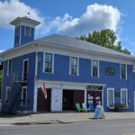
Frequently Asked Questions
No. While entering Baxter State Park takes more planning than other parts of the A.T., it is also one of the most well-resourced places on the Trail. The park reservation staff and rangers are all there to answer your questions and want to help you have a successful visit to the park.
- The Birches: Mid-week, June, and the end of the season in late September and October.
- Campgrounds and KTPs: Mid-week and before school lets out and after it goes back in session (so before mid-June and after Labor Day).
We strongly recommend not planning to visit the park over Labor Day weekend.
Yes, so long as you don’t leave the Trail. So, resupply can be brought to you (be sure to meet your resupply; do not have food left for you as this can harm wildlife). If you leave the Trail to go into town to get your resupply or spend the night, you will have to stay elsewhere in the park.
No. As mentioned above, the Birches campsite was created for long-distance hikers who have hiked continuously northward since Monson and therefore have not been able to make a reservation in advance. If you leave the Trail in the 100 Mile Wilderness, you should make park reservations while in town.
No, only during the height of the northbound thru-hiker season does the Birches fill. Even when the Birches reaches capacity, it’s rare that Baxter staff cannot find hikers another place to stay in the park. In 2025, there were only two nights out of the entire season where the Birches was full and there weren’t other park campsites available. Even when that happens, there are camping options available at Abol Bridge.
Long Distance Hiker permits are free and must be picked up in person at the Katahdin Stream Ranger Station before you head up the mountain. Permits are valid for 7 days from the date they are issued. Rangers are generally at the ranger station from 7:00 to 8:30 am and 4:00 to 5:00 pm. Rangers can often be found nearby outside of these hours.
If you have a Tramily of 5 people or more, break into smaller groups if you plan to stay at the Birches. This way, one group isn’t monopolizing the space. If you do not want to break into smaller groups, stop at the Monson A.T. Visitor Center to chat about making reservations. Northbound thru-hikers can also plan to stay at Abol Bridge or Abol Pines Campground and summit in one day. Note that the group size limit in Baxter is 12 people.
Organized and/or commercial groups (camp groups, Scouts, professionally guided groups, etc.) are not eligible to stay at the Birches.
Since implementing the permit system in 2017, the park has never run out of Long Distance Hiker permits. If permits ever run out, A.T. hikers will still be able to summit Katahdin, they’ll just need to have a reservation and enter the park via the Togue Pond Gate like all other visitors.
The date that the park closes the mountain each year depends on weather. We recommend summiting prior to October 15. The opening date for the summer hiking season also depends on weather and we do not recommend planning to summit before June 1.
See Step 4 above.
No. See Step 2 above.
Yes, and we encourage you to do so! See Step 3 above.
Northbound thru-hikers should keep in mind that reservations often fill up months in advance. Visit the park’s online reservation system or call the reservation line, which is open 7 days a week during the summer. The Monson A.T. Visitor Center can also assist you with reservations before you head into the 100 Mile Wilderness.
For campsite reservations, be sure to check more than just Katahdin Stream. See Step 3 above. Remember that if you have a vehicle in the park, you will have more campground options than what’s listed in this guide. Contact us or Baxter for more info.
If you’re not able to get a campsite reservation for the nights you’d like, then you should try to get a KTP for the day you’d like to summit. Make arrangements to get shuttled into and out of the park if you won’t have a vehicle.
If you’re not able to get a campsite or a KTP reservation, you can try to get any unsold or unclaimed KTP reservations in person:
- Line up at the Togue Pond Gate no earlier than 5:00 am on the day you’d like to summit.
- Park staff will go down the line of cars and if there are any unsold KTPs for that day, you’ll have the chance to claim one.
- If there are no unsold KTPs, you can wait until 7:05 am. At 7:05 am, the park releases any KTPs that have not been claimed (no-shows). Unclaimed KTPs will be given out on a first come, first served basis for anyone still waiting.
If you’ve exhausted all the options above, then you’ll need to try for a different day.
Questions About Your Summit Plans?
Contact the ATC or contact Baxter State Park at 207-723-5140.
Reservations, maps, and daily conditions can all be found on the Baxter State Park website. Read through our Hiker Resource Library for anything else you’d like to know about the A.T. and how to plan for a safe, fun hike.