Why Aren’t There More Bridges on the Appalachian Trail in Maine?
The Appalachian Trail in Maine is famously rugged, but its relatively few bridges have some interesting reasons many hikers might not realize.
Read More

Caitlin Miller
River and stream crossings are one of the most dangerous challenges on the Appalachian Trail (A.T.). Hikers have died in stream crossings along the Trail during major rainstorms. When in doubt about the safety of a river crossing on the A.T., wait for the water to go down or turn around – it is not worth the risk. Pack extra food and supplies so you can be prepared to turn around or wait if necessary.
If a section of the Appalachian Trail is closed or presents a serious safety hazard, hikers may take a designated alternate route or skip those sections entirely and still be eligible to receive 2,000-miler status.
There are sections of the A.T. that have unbridged river and stream crossings, particularly New Hampshire and Maine, that can become impassable after major storms and during spring snowmelt. Elsewhere on the A.T., even a small creek may become dangerous after exceptionally heavy rains or snowmelt. During and for a few days after storm events, it may be best to wait until water levels drop or backtrack to a road to get around a flooded area.
Bridges may be damaged or destroyed by storms and floods, resulting in unanticipated difficulties for hikers. Seek alternate routes if in doubt. Check-in with the ATC visitor centers, check our Trail Updates page, or contact us to get up-to-date information on Trail conditions. Overnight hikers can also register on ATCamp to receive urgent Trail alerts about high water. Other platforms with crowd-sourced information such as FarOut and AllTrails may also have updated condition reports from users.
Most importantly: do not ford a stream when it looks too dangerous.
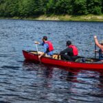
Do not attempt to wade or swim across Maine’s Kennebec River. Dam releases upstream may cause sudden and rapid changes in water depth and current. Two hikers are known to have died attempting to ford the river. The official route of the Trail across the Kennebec is the ferry service for A.T. hikers, provided during peak hiking season.
May 22 through June 30: 9:00 a.m. – 11 a.m.
July 1 through September 30: 9:00 a.m. – 2:00 p.m.
It is important to both mentally and physically prepare for sections of the Trail that have unbridged crossings. Remember that conditions can change on the A.T. at any time – always have the 10 Essentials and remain flexible.

Most of the A.T.’s major unbridged river and stream crossings are in New Hampshire and Maine. There are a few unbridged crossings in other sections that can be dangerous during high water events. Any stream crossing can become dangerous during severe weather events – even bridged crossings.
No matter your level of experience, there are times when stream crossings are too dangerous to cross. When in doubt, turn around or wait for water levels to recede. Five things to watch for that indicate a river is too dangerous to ford:
Throw a stick into the water and see how rapidly the water carries it away. If you cannot walk as fast as it is moving, then it is not safe to cross.
Photo: Long Pond Stream during heavy rainstorms in 2023. The water is certainly flowing faster than a person could walk.
Even a moderate current can knock someone off their feet if the water is high enough. High water can also be an indicator of a recent storm, snowmelt, etc., meaning that the crossing is especially dangerous.
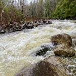
Roger Merchant
Look for muddy, murky water that you cannot see through; surging, churning water; and hazards in the water such as branches and other debris being carried downstream. Shoreline plants and tree trunks may also be submerged that are otherwise not during normal water levels.
Photo: A river crossing clearly in flood stage. Note the churning, murky water, flooded opposite bank, and multiple hazards around and including the bridge. Neither fording nor using the bridge was safe on this day.
This indicates an abnormally powerful current and can also be an indicator that a river is in flood stage.
Such as rapids, trees or branches stuck in the river, or a waterfall, bridge, or dam.
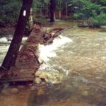
Jean Violette
Don’t assume that the blazed line of sight to the other bank is the path you should follow.
Water levels and currents are dynamic, so a good crossing point on one day may not be safe on another. Just because the blazed crossing route was safe on the day it was laid out does not mean it will be safe during high water.
River crossing diagram courtesy of the Mountain Safety Council of New Zealand. “Run Out” is an area downstream of the planned crossing route that you can use as a bailout or turnaround point if needed.
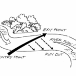

James Timothy Peters
Solo hikers should wait to attempt major crossings until other hikers arrive. Tramilies (trail families) should plan to cross rivers and streams together.
The strongest person should be positioned in front/upstream to help break the current. Group members that are smaller/not as physically strong should be positioned in the middle, with another strong member placed furthest downstream. The Pacific Crest Trail Association (PCTA) has good examples of group crossing techniques depending on the size of your group, as well as some more helpful information on river crossing safety.
Visit the PCTA’s Website
Remember, if you have doubts as to whether a river is safe to cross, don’t cross. Turn around, wait for the water to recede, or use a designated alternative route if one exists.
A good crossing point on the Pleasant River. Note the shallow water that is clear and slow-moving, and that this hiker has unbuckled their pack and is using trekking poles for balance. If the water was deeper or swifter, it may have been appropriate for this hiker to team up with the hikers on the far shore to do a group crossing. It may have also been appropriate for the hiker to face upstream and shuffle across.
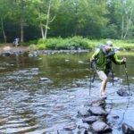
John Bilbrey
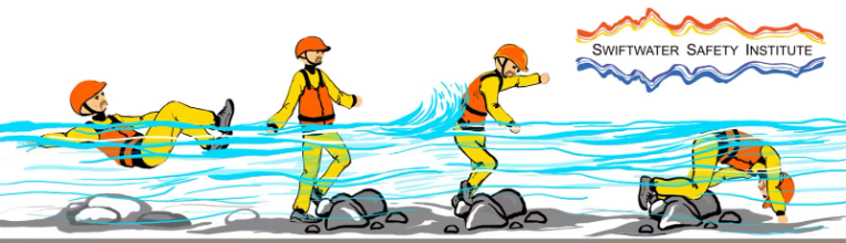
An illustration of foot entrapment. Diagram by Scott Solle, courtesy of the Swiftwater Safety Institute.
The Appalachian Trail in Maine is famously rugged, but its relatively few bridges have some interesting reasons many hikers might not realize.
Read More
Learning how to assess and safely cross rivers and streams before you need to use those skills on the Trail is critical. Practice in a safe location and consider taking a swift water safety course. Click on the hyperlinks below to learn more.
Some information on this page was adapted from Navigation and Hiking Tips by George G. Spearing and information from both the Pacific Crest Trail Association and the Mountain Safety Council of New Zealand.