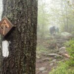
Storm Damage Info for 2026 A.T. Hikers
Hurricane Helene hit the southern Appalachians in late September 2024 and caused widespread, catastrophic destruction. Closures and detours due to the storm are still in effect, and Appalachian Trail (A.T.) hikers must take special precautions to stay safe and help the land heal.
Continue reading for the best ways to plan your A.T. adventure and learn about what to expect in areas with storm damage. We will continue to update our Helene Trail Alert with the latest closures and conditions.
Last updated June 12, 2026
Register & Sign Up for Trail Alerts with ATCamp
When you register your hiking plans on ATCamp.org, you can also sign up to receive urgent Trail alerts to your phone or email while you’re out on the Trail.
Register your hike
Frequently Asked Questions
Nolichucky River Detour (NOBO mile 344.6)
The Chestoa Bridge that the A.T. followed across the river was washed away during the storm. Since bridge construction is expected to begin in 2026 and truck traffic has greatly reduced in the area, a ferry service will not be offered again in 2026. Hikers can either follow the road walk detour (3.6 miles) or shuttle around. Shuttling around the river vs. walking the detour will not impact a hiker’s eligibility for our 2,000-miler program.
Nolichucky River DetourIron Mountain Gap Detour (NOBO mile 360.6)
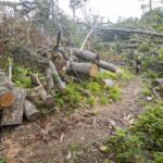
There is a ~6 mile detour around Iron Mountain Gap to route hikers away from a storm debris removal project. This project will reduce wildfire risk by removing downed trees. The project is still underway and uses heavy logging and construction equipment. Because of this, the detour will remain in place until storm debris removal is complete.
The detour is the official route of the Trail and is marked with temporary white plastic blazes.
Iron Mountain Gap DetourVirginia Creeper Trail Detour (NOBO mile 474.5)
Construction work to rebuild the Virginia Creeper National Recreation Trail (Creeper Trail) following damage from Helene began in November 2025. The A.T. is closed from Highway 58 at Straight Branch to Grassy Ridge Road where the Trail is co-aligned with or closely parallels the Creeper Trail outside of Damascus.
A.T. hikers can either take a detour that uses several side trails to route around the closed section (including the Iron Mountain Trail, which was the A.T. until 1972), or shuttle around the closed section. Shuttling around vs. walking the detour will not impact a hiker’s eligibility for our 2,000-miler program.
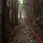
VA Creeper Trail DetourAll of the open sections of the A.T. that were damaged by Helene are passable. However, trees continue to fall that may block the footpath again. Most side trails to primary water sources are open, but some campsites are still covered with downed trees.
- In some places, there are still tangles of downed trees on either side of the Trail. Crews and volunteers are out again this year, clearing debris and pushing trees further back from the Trail.
- Hikers should be prepared for it to be difficult to find campsites and side trails in some areas, and be very careful to not get lost when leaving the footpath for water or to use the bathroom.
- Sun exposure and dehydration is a bigger risk in areas that lost significant tree cover. Pack sun protection and extra water.
- There are a significant number of hazardous trees – trees that are still standing but are dead or were damaged by the storm. These trees are also more susceptible to diseases as the storm compromised many aspects of overall forest health. Always look up before taking a break or picking a campsite. Do not stop or camp within falling distance of a hazardous tree.
- With more sun reaching the forest floor due to tree loss, vegetation grows much more quickly. In summer, be prepared for thick overgrowth that may obscure the footpath. This includes nettles, briars, and poison ivy, and may mean that you’re more likely to pick up ticks through these areas. Wearing long pants can help protect you. Learn more about tick safety.
Remember, the severity and scale of Helene means storm damaged areas will remain dynamic for years.
Trees will continue to fall. Soil will continue to erode and move. Don’t be afraid to turn around if you encounter new, uncleared damage. Continue reading this blog for more details on what to expect in storm-damaged areas and how to stay safe.
No. Just because other hikers say that an area is passable does not mean that it is safe.
The area around Iron Mountain Gap and the closed section along the VA Creeper Trail are closed for both your safety and the safety of crews working. Always stay out of closed sections.
Official closures from the U.S. Forest Service are legally binding, meaning that you can be fined and/or arrested for being in closed areas.
Volunteers, U.S. Forest Service staff, ATC staff, and other partners are hard at work this year to continue repairing damage. You can assist by reporting Trail issues such as new blowdowns, erosion, overgrowth, etc. to trailconditions@appalachiantrail.org.
When reporting Trail conditions, it’s extremely helpful to include:
- Precise location: GPS coordinates, Trail mileage (e.g. NOBO mile 348.7), or distance from closest waypoint (e.g. 0.3 miles north of Moreland Gap Shelter).
- What the issue is with as much detail as possible. For example “There’s a short section of Trail at mile 356.2 that has started eroding downhill. It’s about a 10 foot section that has started sliding down the side of the slope, including some small rocks.”
- A photo whenever possible, and some common item in the photo for scale. For example, putting your hat on a blowdown or leaning your trekking pole against it and including that in the photo can be really helpful for maintainers to know what tools they need to bring to address the issue.
Use your best judgement and only approach an issue on the Trail if its safe to do so. Do not go near precariously hanging trees, severely eroded slopes, etc. Take a photo from a safe distance and then find a safe way around or turn around.
Yes, there are long-term fire restrictions in place in the Roan Highlands along the NC/TN state line and the Mt. Rogers High Country in VA. These sections of Trail are home to Southern Appalachian spruce-fire forests. These globally rare and threatened forests are only found in the highest and coldest parts of the Southern Blue Ridge mountains, and are home to a host of threatened and endangered species found nowhere else in the world.
These forests were severely damaged by Helene. The blown-over fir and spruce trees are extremely flammable as they dry out, leaving these areas at high risk for wildfire. You can help protect one of the A.T.’s most unique ecosystems by not having campfires. Commercially available camp stoves with on/off valves are allowed (but please use with care).
Visit the Southern Appalachian Spruce Restoration Initiative to learn more more about these special forests.
Pack Flexibility, Patience, & Good Judgment
Areas hit by Hurricane Helene are still changing and evolving, even more than a year later, and will continue to do so. Good judgment and the ability to safely adapt to changing conditions are as important for A.T. hikers as the 10 Essentials.
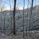
- Understand that areas with severe storm damage are dynamic. The forest has been completely changed, with some areas losing more than 90% of their tree cover. Just because a section is open when you start your hike does not mean it will stay open and vice versa.
- Trees will continue to fall as they die and rot,
- High winds and other storms will have a bigger impact on the damaged landscape,
- Rain could lead to landslides now that these areas no longer have roots holding the soil in place,
- Storm debris means that wildfires are a big risk.
- Remain flexible and be prepared to change your plans if needed.
- It is much easier to mentally prepare for changes before you leave for your hike. Take time while you plan to think through what it would look like to skip sections, skip north of the worst storm damage, or end your hike early.
- Budget for the possibility of changing plans. Skipping sections and flip-flopping will add transportation, lodging, and other costs. Having emergency funds built into your hike budget will let you be flexible when you need to be.
- Exercise good judgment and err on the side of caution. If you come across an open stretch of the A.T. that has new damage and you are unsure if it’s safe to go through, turn around. We know that it is deflating to backtrack or turn around before your destination, but nothing is worth your safety. The Trail will be waiting for you once it is cleared and repaired.
- Please be patient. Again, areas with severe storm damage are dynamic. Conditions will change. Many Trail towns and sections of the A.T. will still bear the scars of the storm. You can show your care for the A.T. and the Trail community by giving others grace as we all rebuild.
- Stay out of closed sections. Sections of the A.T. are rarely closed and only for very good reasons, usually for hiker safety. Staying out of closed sections protects you and gives crews room to work.
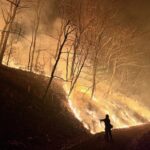
Be Aware of Heightened Wildfire Risk
You can help the land heal by forgoing campfires in storm-damaged areas.
In the worst-hit areas, 90% of trees were knocked down by the storm. All of these downed trees create the perfect fuel source for wildfires to spread quickly, which could have devastating effects on the already damaged landscape. The southern A.T. is also in a severe to extreme drought. Hot, dry, windy conditions means that fire danger is high and you should not have a campfire, regardless of whether official burn bans are in place.
Wildfires pose a serious risk to both hikers and local communities that border the forest. Learn more about the fire danger created by Hurricane Helene damage from the U.S. Forest Service.
Wildfire risk remains even after temporary rains, especially in the Roan Highlands in NC/TN and Mt Rogers High Country in southwest VA. These areas are home to rare and critically imperiled southern spruce-fir forest. Damaged spruce-fir trees dry out extremely quickly and are very flammable.
The ATC strongly recommends that A.T. hikers not have campfires and exercise caution when using camp stoves in storm damaged areas, regardless of whether official burn bans are in place.
There is an official burn ban in the Roan Highlands from Hughes Gap to Doll Flats (NOBO miles 374.2 to 392.6) and in the Mt. Rogers High Country of VA from Beech Mountain Road to Massie Gap (NOBO mile 489.4 to 502.4). Check for temporary burn bans on our Trail Updates page.

Essential Skill
Wildfire Safety
Look Up Before Stopping
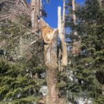
Many of the trees left standing in areas hit by Helene are now dead, damaged, and at greater risk of disease.
These trees, sometimes called hazard trees, could fall at anytime, especially during windy weather. While there may be hazardous trees anywhere along the A.T., they are more numerous in storm damaged areas. The ATC has received reports that ground displacement and erosion caused by the hurricane is causing new blowdowns to fall faster than average.
Do not stop or camp under dead, damaged, leaning, or diseased trees. Look up before stopping or setting up camp and make sure you are not within the tree’s length or under any large, dead branches.
Pay attention during storms and on windy days. Hazardous trees are more likely to fall or break off in windy, stormy weather. In especially bad weather, it may even be safer to stop for the day and set up camp away from any hazardous trees than to hike through an area with many lining the footpath.
Essential Skill
Identifying Hazard Trees
Use a Bear Canister
It could already be hard on the A.T. to find a good bear hang tree. Now, with many mature trees knocked over, there are even fewer opportunities to do a proper bear hang in storm-damaged areas.
Its also important to keep in mind that not all A.T. overnight sites have provided food storage (bear boxes, cables, etc.) and dispersed camping sites don’t have these, either.
Bear Encounter Reports were up 75% in 2025. Bear canisters are the surest and most flexible way to store your food on the A.T. You can protect yourself, other hikers, and bears by using a canister.
Essential Skill
Proper Food Storage
Report Bear Encounters
Your report will help reduce human/bear conflicts on the A.T. by alerting land managers to conflicts early on. By catching issues early, managers can work with wildlife experts to implement measures to help bears return to their natural behaviors and minimize the need for bears to be removed or euthanized.
Reported bear incidents are shared with our land management partners and listed on our Trail Updates page.
Please submit a report if a bear:
- Entered a campsite or shelter area.
- Attempted to (or did) steal food.
- Was aggressive toward you, another hiker, or a pet.
- Damaged property.
- Was following you while you were hiking.
- Was acting strangely (e.g. was not scared by loud noises, was persistent in its pursuit of food and/or humans, followed you or another hiker while fixating intently, did not show fear of humans, seemed sick or diseased).

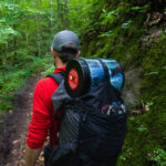
Bring a Map, Compass, and Sun Protection
Downed trees and overgrowth can make the Trail harder to follow.
Debris left by the storm may make it difficult to find your way, especially off of the footpath while finding campsites and secondary water sources (springs and streams that aren’t at designated overnight sites, like shelters). Trees will continue to fall due to further erosion, other storms, and diseases that the trees are now prone to due to the storm’s impacts on overall forest health. So even though the footpath is now passable, conditions can change at anytime on the A.T.
With so much tree cover gone, a lot more sunlight is reaching the forest floor now, too, which means that vegetation along the footpath grows much faster. Club volunteers report needing to spend more time cutting back brush to keep the footpath visible in storm-damaged areas. The Trail may be harder to find in late spring through early fall due to more rapid growth.
This also means less cover for hikers (but also more views!). Don’t forget to bring sunscreen and a hat!
Apps and PDF maps are not sufficient – apps can have glitches and phones can die. Turn around if you come to a section and cannot easily find the Trail. Be extremely careful when leaving the footpath to find a campsite, get water, or use the bathroom.
Volunteers with the Piedmont Appalachian Trail Hikers report that there are several downed trees across Lick Creek (NOBO mile 564.1) upstream of the ford. We strongly recommend against using these trees to cross. Learn more in our Lick Creek update.
Essential Skill
How to Use a Compass
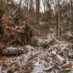
Watch for Unstable Ground
With fewer tree roots to hold the ground in place, landslides are still a risk in storm-damaged areas.
Sections of the footpath (also called the tread or treadway) may have still have severe erosion. Other sections will be soft and unstable. There may be large craters in the treadway due to uprooted trees, which are especially hard to see in snow.
- Test soft or unstable-looking sections with a trekking pole or stick before stepping on them. Be especially careful on sections that follow a steep sidehill/slope.
- Look uphill for large, loose boulders.
- Do not cross slides or attempt to go above them. If the ground has slid away, turn around. It could still be unstable and weight on the ground may cause a further slide.
- Follow the weather before your hike and check it before you leave town. Heavy rain or snow can increase the risk of landslides.
Essential Knowledge
Check Conditions Before You Go
What to Do If You Run Into a Trail Crew
A.T. Maintaining Clubs, USFS staff, and ATC crews have been hard at work since Helene hit repairing the damage and will continue to work on storm-damaged sections this year. You can support their efforts and the Trail’s recovery by giving them room to work and making sure its safe to pass before continuing on your way.
- Never try to pass a working crew or Trail maintainer until you are certain that they know you are there and have paused work to let you pass. This is critical for crews using chainsaws and heavy equipment like rigging.
- Stay as far away as possible from saw crews until you are certain that they know you are there. Make sure you get a response from them indicating that they see you (hand wave, a call out, etc.) and that they turn their chainsaw off/stop sawing before you continue.
- If the crew cannot see you unless you get close because of the terrain, wait for a pause in work and yell out. Do not continue until you get a verbal response back letting you know it’s safe to approach.
- Listen for the sound of folks working. If you hear the buzz of chainsaws or clanking of tools up ahead, slow down and approach with caution.
- Look for signs. Crews often (but not always!) put up signs or may even post crew members at either end of their project area. Follow instructions on signs and respect these crew members, waiting if necessary until they give you the all-clear to proceed. This is also a great chance to ask questions about upcoming shelters, water sources, and towns!
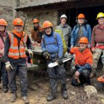
Volunteer sawyers from 5 A.T. Clubs gather at Trimpi Shelter. Photo by Pete Irvine.
Last but not least, please say thank you! Many of the crew members you’ll run into on the A.T. are volunteers. Everyone you meet working on the Trail is there because they love it and want to keep it open for everyone. A simple thank you goes a long way toward making these folks feel appreciated for their hard work!
Want to Give Back to the Trail by Volunteering?
A.T. Clubs welcome volunteers to join them on a workday or you can sign up for a multi-day volunteer trail crew experience. There will also be more Helene repair-related Trail Crew projects in 2026.
Check out all our volunteer opportunities and sign up for our volunteer newsletter by clicking the button below.
Become a Volunteer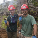
Ben Earp Photography
Trail Towns & Giving Back
Many small mountain towns along the Trail rely on hiker business during the spring, summer, and fall months. These Trail towns were hit particularly hard by Helene and many are still recovering.
North Carolina
- Hot Springs, NC
- Recovery updates: Hot Springs Recovery Hub
- Status of hiker services: Hot Springs Tourism
- Elk Park, NC
- Recovery updates & resources: Town of Banner Elk
Tennessee
- Roan Mountain, TN
- Hampton, TN
- Shady Valley, TN
- Erwin, TN
- Recovery updates & information: Visit Unicoi County
Virginia
- Damascus, VA page.
- Recovery updates: Town of Damascus
Respect Trail Closures, Detours, and Practice Wildfire Safety
Entering closed areas/ignoring detours can slow recovery work, since doing so means that crews need to stop work and turn off machinery for your safety and theirs. Locals and Trail neighbors have expressed the importance of giving these crews room to work so they can complete their projects as soon as possible.
We’ve also heard that many locals in storm-damaged areas are very concerned about the high wildfire risk. Help keep yourself, other hikers, and the surrounding communities safe by respecting burn bans and not having a campfire in storm-damaged areas, regardless of whether an official burn ban is in place.
Support Local Businesses
You can help recovery efforts by patronizing local businesses. If your budget allows:
- Buy gear and gear replacements from locally owned outfitters.
- Schedule rides with shuttle providers instead of hitchhiking or yogi-ing a ride at the trailhead.
- Plan zero days in impacted towns. Hikers tend to spend more money in town the longer they are off Trail, so
- spending your zero days in towns hit by the storm will help give the local economy a boost.
- There’s so much going on in Trail towns besides the A.T.! Plan your visit around and attend local events and festivals if you can.
Volunteering for recovery efforts in towns
If you’d like to help with recovery efforts in towns or at hostels along the way, please call ahead first to ask about opportunities. Help will be welcomed in many places, but showing up unannounced or self-deploying can take up valuable resources, create confusion, or slow things down.
Give Back
The ATC and our partners are already posting volunteer opportunities to help rebuild the A.T. and will continue to do so into 2026. Sign up for our volunteer newsletter to receive information about opportunities, including our Trail crews.
Receive Volunteer OpportunitiesYou can also donate to the ATC and support our work to repair, rebuild, and reconnect the Trail.
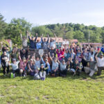
Ben Earp
Happy Trails!
Remember that we are all stewards of this special place. The A.T. has flourished for more than 100 years and, with your help and careful planning, will remain a premier National Scenic Trail for another 100 years and more!