Understanding the basics

Planning a day hike

The Basics: How far to go and types of day hikes

How far do I go? You’ll want to consider these factors:

  • Length – Start by asking, “how many hours do I want to hike?” Multiply that by 1.5 and you’ve got a good estimate of the mileage (even if you can walk 3 mph around home). Adjust as you research and learn more about the terrain and decide what kind of A.T. experience you want to have.
  • Destination features – Is there a special highlight that will be your goal? Popular day-hikes are often up-and back to the top of a mountain or a rocky outcropping where there is a view. Sometimes the destination may be lake, a waterfall, a grassy “bald” or meadow. Or it could be a trailside or cultural feature.  Often, destination hikes (especially to expansive mountaintop views) require a substantial uphill climb with a significant descent on the return.
  • Nature walk – Discovering the rich variety of trees, flowers, wildlife, birds, mosses, mushrooms in their natural habitat can be both thrilling and calming. Using all your senses to appreciate the wonders of nature can be restorative. You might want a camera, binoculars, or even a magnifying glass. Plan significantly fewer miles for this kind of hike.
  • Difficulty – Hikes on the A.T. can range from easy, beginner-friendly, to extremely difficult. Elevation gain (the amount of climbing) and the smoothness of the footpath (or lack of it due to rocks and roots) are the primary elements of difficulty.  Most states have some short, easy sections (Georgia, New Hampshire, and Maine have the fewest). Almost every state has sections that some (or all) hikers would consider difficult. Know what you’ll be getting into so you pick the hike that’s right for you and adjust your mileage (or your location) accordingly.
  • Elevation gain – This is a huge factor in determining the difficulty of a hike. Many parts of the A.T. are hilly or downright steep, although some are flat or gentle. If you’re in great shape a hike with a lot of elevation gain may be a fun challenge, if you’re not, not so much.  The more elevation gain (uphill hiking) the slower your pace will be. If the trail climbs 100 feet in a mile, that’s pretty gentle. A climb of 400′ feet per mile is a serious workout, and at 800 or 1000 feet a mile you may be using your hands to climb up boulders and the seat of your pants to scramble down.
  • Terrain – Occasionally the A.T. offers a gentle “walk in the woods,” on a wide, smooth, flat path. More often the trail is narrow, wide enough for just one person. In many areas the terrain may include some rocky, muddy, or root-covered sections. This may slow your progress and may be physically or mentally challenging even when the trail is flat. In Maine especially, the hike may involve river crossings, so you’ll need to plan for that.
  • Other breaks to factor in – Whether you’re taking a nature hike or one more focused on physical challenge, allow time to soak in the views, enjoy wildlife and flowers along the way, or stop and chat with some friendly people you meet. Allow time to pull out your map occasionally, take photos, and allow time for lunch, rest, and bathroom breaks.

TIP: It’s usually best to plan on fewer miles than you anticipate you’ll cover.

Hike Types

Did you know day hikes on the A.T. come in a variety of formats? Some require you to retrace your steps and some don’t, some require only one vehicle, and some require two.

Up and back – Hike to a destination or as far as time allows, turn around, and return the same way to your starting point, retracing your steps. Sometimes this is called round trip (as in a “round trip” flight), or out-and-back. Requires only one vehicle.

Loop – Two or more connecting trails that may form a circle, triangle, square, figure eight, or even banana shape that allow you to return to your starting place without re-tracing your steps. This is most often possible where the A.T. passes through other state or national parks and forests, and other connecting trails exist. Requires only one vehicle.

Road to road – The 2200-mile A.T. is crossed by hundreds of roads, offering practically endless opportunities to hike from one road crossing to the next. This allows you to see the greatest amount of the A.T. for the time you are walking. However, it does require at least two cars and a lot of driving, or one car and another person and their vehicle to shuttle you. If you arrange a shuttle, it’s best to do the shuttle before you start and hike back to your car, as there may not be cell phone service at the parking area.

One approach to reduce the amount of driving is a “key swap,” where your group splits in two, starts at opposite ends and exchanges car keys when you meet.

Most road crossings have parking for hikers, but not all. Road crossings are often 5-10 miles apart, but can range from 1 to 40 miles apart.

Inn to Inn – Two locations on the Appalachian Trail offer fantastic opportunities to do multiple day hikes in a row and end the day with a bed, shower, and a meal.

  • Shenandoah National Park in Virginia is perfect for novices eager to get a taste of mountain hiking and experience some of the A.T.’s gentler grades in the Blue Ridge Mountains. You can do a three-day hike with beautiful scenery and stay at lodge or cabin along the famed, scenic Skyline Drive, where meals are available, from May through October. Read an article about what it’s like to Hike Hike In Comfort from lodge to lodge in Shenandoah National Park!
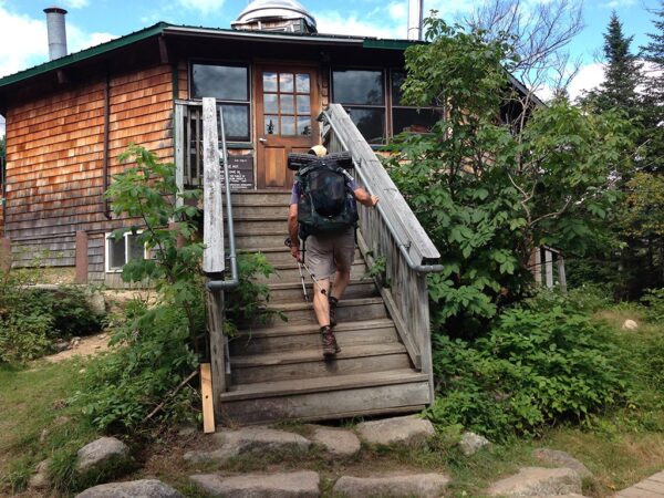
  • The White Mountains of New Hampshireoffer extreme and spectacular hiking above treeline that athletic, experienced, and ambitious hikers will love. The Appalachian Mountain Club’s system of eight alpine-style huts in the White Mountains offer cozy bunks and home-cooked meals near the summits of the highest mountains of New England. These are extremely popular so plan your trips months in advance!
  • Learn more about to plan these and other Inn-to-Inn Hikes on the A.T.

Planning a family hike? Check out our tips here!