
How Long is the Appalachian Trail?
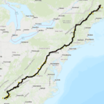
The official length of the Appalachian Trail (A.T.) is 2,197.9 miles as of 2026. The Trail runs through 14 states from Springer Mountain in Georgia to Katahdin in Maine.
The A.T. passes through eight different national forests, six national park units and numerous state parks, forests, and game lands.
The mileage is updated annually as sections are relocated or detoured.
How to Hike the Appalachian Trail
There’s no single way to experience the Appalachian Trail. The A.T. has hundreds of access points and is within a few hours’ drive of millions of Americans. Learn more about the most common ways people take on the Trail.

Kemper Mills Fant


Michael Rosenberg
How is the A.T. Marked?
The A.T. is marked for daylight travel in both directions using a system of white “blazes,” rectangles of white paint 2 inches wide and 6 inches high. Blazes are most often found on trees, posts, and rocks. Side trails and shelter trails use blue blazes.
Distance between blazes varies, but if you have gone a few hundred yards without seeing a blaze, stop and retrace your steps until you find one. Then, check to make sure you haven’t missed a turn. When your map or guidebook and the blazes disagree, follow the blazes.
In the 25 federally designated wilderness areas the A.T. passes through, found in Georgia through Virginia and in Vermont and New Hampshire, blazes are intentionally less frequent, sometimes up to a quarter mile apart. Side trails may not be marked. This is intended to preserve the wilderness character of the land. Carrying a map and compass is especially important in these areas.

Single White Blazes
White blazes mark the A.T. and may be located on trees, rocks, posts, or guardrails, among other places. Distance between blazes varies depending on the terrain and section of the Trail.

Double White Blazes
Two white blazes, one above the other, signal an obscure turn, route changes, an incoming side trail, or other situation that requires you to be especially alert to changes in direction. Sometimes the two blazes will be offset in the direction of the turn.

Rock Cairns
Above the treeline, piled rocks called cairns may identify the route where snow or fog could obscure painted blazes.
Frequently Asked Questions
The official length of the Appalachian Trail in 2026 is 2,197.9 miles from Springer Mountain in Georgia to Katahdin in Maine.
The Appalachian Trail’s southern terminus is Springer Mountain in Georgia, and its northern terminus is Katahdin in Baxter State Park, Maine.
A thru-hike of the entire Trail typically takes around six months. Most northbound thru-hikers start in Georgia between late February and early April and aim to reach Katahdin before Baxter State Park closes in mid-October.
Section hikers complete the Trail over multiple years, and many people enjoy the A.T. through day hikes and shorter backpacking trips.
As the world’s longest hiking-only footpath, there are many ways to hike the Appalachian Trail. One of the most common ways people hike the A.T. is through day hikes, where they return home the same day. Backpackers carry gear for multiple nights out.
Long-distance hikers include section hikers, who work toward completing the entire Trail over multiple years, and thru-hikers, who complete the whole Trail within 12 months.
Hikers may choose to hike solo or together with friends, family, or community groups. Dogs are welcome on most sections of the A.T., with some exceptions and leash requirements.
Have more questions? Visit our full FAQ page for more information about hiking the A.T.
Planning Your Trip
Transportation & Parking
The A.T. has hundreds of access points along its length where you can park and get on the Trail. Some public transportation and shuttle services are also available.
Transportation & ParkingAccessibility
There are opportunities for every ability on the A.T. Find wheelchair accessible routes, multi-use sections, and more.
AccessibilityPermits & Fees
Some parts of the Trail require an entrance fee and permit, and some places require fees for camping.
Permits & FeesEssential Skills
Learn the essential skills every hiker needs to prepare for the Appalachian Trail and protect its landscapes.
Essential SkillsHiker Prep Series
Before heading out to the Appalachian Trail for your long-distance hike, learn ways to have a safe and enjoyable A.T. experience.
Hiker Prep SeriesFinding a Hike
At over 2,190 miles, there are literally thousands of incredible places to visit on the A.T.!
Find parking, popular vistas, campsites, and more with the free, interactive A.T. map and start planning your trip to the Trail.
Interactive Map
Register Your Hike with ATCamp
Avoid crowded trailheads and campsites by checking busy times and registering your hike with ATCamp. You can also opt-in to receive urgent Trail alerts and other information while on the Trail.

Stewardship & Responsibility


Emma Getz

Report an Incident
While the Appalachian Trail is a relatively safe place to visit, that does not mean that there are not potential dangers while you are hiking or camping. If you see something, say something — this will help us keep the A.T. as safe as possible for our visitors.
Report an Incident