Virginia: Andy Layne Side Trail Detour
VA | Detour
152 DAYS AGO
02/09/2026
There is a temporary detour in effect for the lower portion of the Andy Layne Trail that routes hikers away from construction activities on Roanoke Cement property. The Andy Layne Trail is an Appalachian Trail (A.T.) side trail that provides access to Tinker Cliffs and is marked by blue blazes (NOBO mile 720.6).
Hikers can access the detour from a field and gravel parking area a half mile south of the North Mountain trailhead (the old Andy Layne trailhead) on Catawba Road/VA 779. The temporary parking area is marked by a signboard and a fenced area containing a large solar panel. The blue-blazed detour leaves from the gravel pull-off and winds 0.4 mi through a field before connecting with the Andy Layne Trail between Little Catawba Creek and Catawba Creek, near a fence gate. See the map below.
For backpackers doing the Triple Crown loop:
You’ll need to walk along Catawba Road/VA 779 for 0.5 miles from the new detour parking area and the Catawba Valley Trail, which connects with the North Mountain Trail. Be extremely careful walking along the road, do not walk along the road at night, and make sure cars can see you. There is little to no shoulder along Catawba Road/VA 779.
More Info:
For more information about the project and timeline, visit Roanoke Cement’s website. For information about visiting the Virginia Triple Crown (Dragon’s Tooth, McAfee Knob, and Tinker Cliffs), including maps and parking info, visit the Roanoke Appalachian Trail Club’s website.
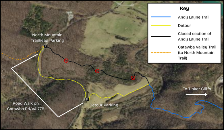
Click image for larger version of the map.