

SW Virginia: VA Creeper Trail Closure & Detour
VA | Detour
69 DAYS AGO
12/10/2025
Construction work to rebuild the Virginia Creeper National Recreation Trail (Creeper Trail) began this month. The trail was heavily damaged by Hurricane Helene in the fall of 2024 and extensive work is needed to repair the path and trestle bridges that were destroyed in the storm. The Appalachian Trail (A.T.) is co-aligned with or closely parallels the Creeper Trail for several miles north of Damascus.
Starting today, the U.S. Forest Service is closing the A.T. from Highway 58 at Straight Branch to Grassy Ridge Road/VA 859 (NOBO miles 476.6.0 to 485.8).
Hikers must stay out of closed area for their safety and the safety of crews working. Construction is expected to last one year.
Additional construction-related closures include:
- Straight Branch Trailhead (NOBO mile 476.6)
- Creek Junction Trailhead (NOBO mile 484.6)
- The Creeper Trail from Trestle 16 in the Town of Damascus to the North Carolina state line just past Whitetop Station.
- Non-A.T. closures: Whitetop Laurel Fishing Trail (FST 4645), Taylors Valley Spur (FST 465), Whitetop Station Parking Lot & Trailhead, and Green Cove Parking Lot & Facility.
A.T. hikers have two options to continue their journey until construction is done, listed below. Both options are acceptable for the ATC’s 2,000-miler program.
Option A: Detour around the closed section on the Iron Mountain Trail, Flat Top Trail, and Mt. Rogers Trail. See the map at the bottom of this post.
This temporary detour will be signed and is shown in the map below. This is the best option for hikers who want a continuous walking route. The Iron Mountain Trail was the route of the A.T. until 1972, so taking the detour is a also fun way to retro blaze!
Total Detour Length: 20.9 miles (temporarily routing around 22.8 A.T. miles, including the closed section).
Important notes for hikers about this detour:
- Wear blaze orange as hunting is popular along the Iron Mountain Trail, including hunting with the use of dogs.
- Sections of the Iron Mountain Trail are multi-use. Stay alert and share the trail.
- Mountain bikes and horses are allowed in some areas.
- Motorized use is allowed on some sections.
- We highly recommend getting an updated paper map of this area. You can purchase maps through our online store or at local outfitters in Damascus.
NOBO (northbound) Directions:
- Continue northbound on the A.T. from Highway 58 up the steps and into the woods. In 2.5 miles, take the blue-blazed Iron Mountain Spur Trail left uphill.
- Follow the spur trail for 0.2 mile until you come to the yellow-blazed Iron Mountain Trail. Turn right, and follow the Iron Mountain Trail for a total of 15.3 miles.
- You’ll pass several other side trails along the way that lead to different campgrounds and roads within the Mt. Rogers National Recreation Area. The Iron Mountain Trail also follows several roads/old woods roads at different points. Be sure to follow the signs marking the detour route and pay attention at intersections.
- There are two historic A.T. shelters and one campsite along the Iron Mountain Trail that have reliable water sources and are still available for camping. The following overnight sites are listed from south to north from the Iron Mountain Spur Trail:
- Sandy Flats Campsite at mile 4.8
- Straight Branch Shelter at mile 9.7
- Cherry Tree Shelter at mile 15.3
- At Cherry Tree Shelter, bear right (south) onto the blue-blazed Flat Top Trail and follow it for 1.7 miles to the Fairwood Valley parking area. Follow the signs marking the detour. Portions of the Flat Top Trail follow a gravel roadbed.
- Walk through the gravel parking area to VA 603, a paved state highway. Cross VA 603 diagonally and turn left onto the Mt. Rogers Trail boardwalk.
- Follow Mount Rogers Trail 3.9 miles, passing a junction with the Lewis Fork Spur Trail at 2.1 miles. The Mt. Rogers Trail is blazed blue.
- The Mount Rogers Trail terminates at the A.T. Stay left to continue northbound. Thomas Knob Shelter is 2 miles further.
SOBO (southbound Directions:
- 2.1 miles south of Thomas Knob Shelter, turn right onto the Mt. Rogers Trail (blue blazed). Follow it for 3.9 miles down to VA 603.
- Cross the paved VA 603 and walk through the gravel parking area to the Flat Top Trail, marked with blue blazes.
- Follow the Flat Top Trail for 1.7 miles until you get to Cherry Tree Shelter. At the shelter, turn left onto the yellow-blazed Iron Mtn Trail. You’ll follow the Iron Mtn Trail for a total of 15.3 miles.
- You’ll pass several other side trails along the way that lead to different campgrounds and roads within the Mt. Rogers National Recreation Area. The Iron Mountain Trail also follows several roads/old woods roads at different points. Be sure to follow the signs marking the detour route and pay attention at intersections.
- Besides Cherry Tree, there is one other historic A.T. shelter and one campsite along the Iron Mountain Trail that have reliable water sources and are still available for camping. From south to north from Cherry Tree Shelter:
- Straight Branch Shelter at mile 5.6;
- Sandy Flats Campsite at mile 10.5;
- Continue on the Iron Mountain Trail until you reach the Iron Mountain Spur Trail on the left. The spur trail connects to the A.T. in 0.2 miles. When you reach the A.T., turn right to continue on the A.T. southbound toward Damascus. Highway 58 is 2.5 farther.
Option B: Get a shuttle to/from Damascus and Grassy Ridge Road/VA-859.
Grassy Ridge Road is the northern boundary of the construction closure at NOBO mile 485.8. NOBO hikers can pick-up the A.T. northbound from here. SOBOs can get picked up and head into town from here. This is the best option for hikers who want to miss as little of the A.T. as possible. Note that Grassy Ridge Road is a narrow dirt road with no parking.
SOBOs: There is no cell reception at Grassy Ridge Road, so make shuttle plans in advance.
There are several local shuttlers in Damascus and the surrounding area. Visit our Damascus Trail Center or local outfitters for more information, or consult an updated guidebook or FarOut.
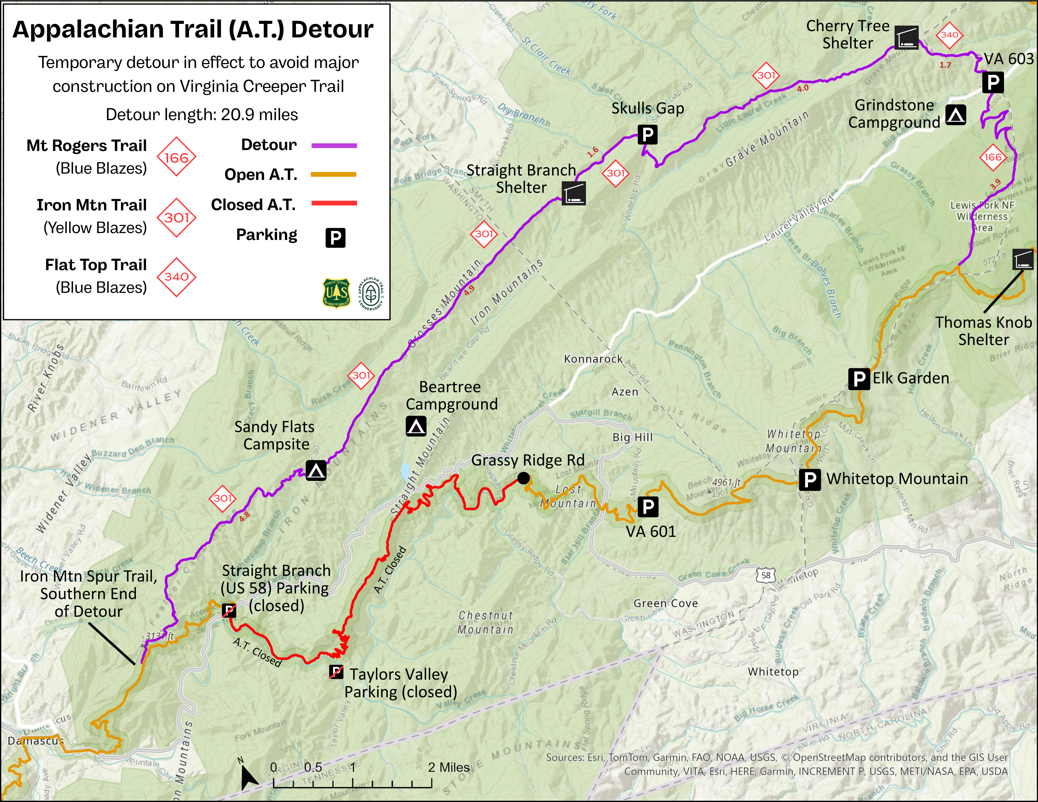
Click the image for a larger, printable version.