
Improving Nights in the Woods
Making overnight sites on the Appalachian Trail more sustainable is essential to protect the Trail experience and the enjoyment and comfort of visitors.

Visitor Use Management (VUM) is essentially everything the ATC and the Trail’s Cooperative Management partners do to make the Appalachian National Scenic Trail available to visitors.
The goal of Visitor Use Management for the Appalachian Trail (A.T.) is to balance the protection of the natural and cultural resources and visitor experiences with providing sustainable recreational access.
Design, construction, maintenance, management and protection of the footpath, trailway, and A.T. overnight sites.
Outreach and education to A.T. visitors on and off-Trail to help them prepare for their visit and understand how to leave the A.T. and the trailway better than they found it.
Minimize misuse of the A.T. and trailway. Misuse causes negative impacts to all the qualities that make the Trail so special — unique plants and animals, rare habitats, opportunities for solitude, and connection with the natural world.
The “trailway” is the acreage around the A.T. dedicated to enhancing the A.T. experience, typically a minimum of 500 feet on either side of the Trail, and along much of the Trail up to 0.5-mile on either side of the Trail.
As a National Scenic Trail, the A.T. has a “nature and purpose” statement and comprehensive management plan required by the National Trails System Act. Additional management direction comes from federal, state, and local land managers responsible for the areas the Trail crosses.
Together, the ATC, local A.T. Clubs, state and federal agencies, and Congress provide direction for how the A.T. is managed and the vision for sustainable overnight sites and protection of the A.T. experience.
Additionally, VUM is part of ATC’s Strategic Plan, with the aim of protecting the experience defined in A.T. management direction as well as making the footpath and its overnight sites sustainable.
The ATC’s Stewardship Council and its Trail Management Committee provide essential leadership and support for the ATC’s VUM work.
The Stewardship Council provides guidance on how the A.T. is cared for and protected across key issues affecting Trail maintenance, resource protection, and visitor use. Through its committees and partnerships, the Council supports long-term planning and consistent stewardship along the Trail.
The Trail Management Committee (TMC), a committee of the Stewardship Council, plays a central role in developing and optimizing VUM tools and planning. Its members include volunteers active in local A.T. management, other subject matter experts, public agency staff, and ATC staff. The TMC focuses on making VUM tools more user-friendly and efficient to better inform local A.T. management.
A.T. visionaries Benton MacKaye or Myron Avery likely could not have predicted how the A.T. would become an internationally revered hiking destination. And they certainly didn’t predict that the Trail would become one of the most visited units of the U.S. National Parks!
Original A.T. VUM focused on providing a continuous route for the Trail, painting blazes, brush clearing, and occasional signage, with hundreds of miles of the A.T. following roads. As the appeal of the A.T. increased, it became one of the first Congressionally-designated national scenic trails through the National Trails System Act, which allowed acquisition of adjacent lands for relocating the footpath from roads and highways to more natural and scenic settings.

Benton MacKaye and Myron Avery
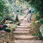
As visitor use grew, so did negative impacts, like user-created expansion of the footpath and overnight sites (pictured). The modern VUM tools and methods aim to ensure more sustainable features to protect the A.T. experience for future generations.
User-created expansion of overnight sites
Anonymous mobile data and on-the-ground visitor counts help local A.T. managers and partners make timely, well-informed decisions about visitor use management on the A.T.
2025 visitation data coming soon.


Voluntary camper and hiker registration through ATCamp registration also helps provide the ATC with data on the overall use of the Trail, which helps the ATC, volunteer Clubs, and agency partners best manage the Trail and Trail resources. Visit ATcamp.org

Local A.T. management partners produce a gap analysis of current vs. desired A.T. experience, based on six A.T. experience zones, primitive to urban.
Local A.T. management partners complete a checklist of overnight site conditions and attributes to highlight needed action and/or spur planning discussions.

ATC seasonal staff compile a comprehensive inventory of the location, size and condition of all A.T. overnight sites, both manager-recognized and user-created.

A summary of A.T. campsite inventory data.

Local A.T. management partners and ATC staff minimize group impacts and optimize the A.T. experience with info on where & how groups use the Trail.
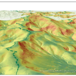
A remote sensing technique that uses an aerial pulsed laser to measure distances and create very accurate 3D models of the Earth’s surface. ATC GIS staff use LiDAR to identify optimal overnight site locations.
ATC staff visualize and make sense of the data collected through ATX, OSFAT, overnight site inventory, CSI, VRI, G.O.R.P. and RIMS, and add critical trailway terrain information with LiDAR to inform local A.T. management partner decisions on trail stewardship.
The ATC facilitates formal VUM planning, currently at six locations along the A.T., using the federal Interagency Visitor Use Management Council’s 14 step planning framework to address crowding and resource damage. All six of these areas, as well as the A.T. as a whole, have experienced significant positive outcomes from their formal VUM planning.


Your gift for the A.T. will go 2x as far with the 2,000-Miler Match!
A group of 2,000-Milers are matching every gift made to the ATC up to $101,000 before 3/31.
Give Now