Learn More

Species Monitoring

Help protect rare species on the Appalachian Trail

To help protect rare species populations, we coordinate a volunteer-based monitoring program to track the vitality of the most rare and most threatened plant populations. Since 1991, more than 200 volunteers have been trained to identify rare species as well as some of the likely threats to these plant populations. Volunteers are then asked to report their rare plant observations, using National Park Service monitoring protocols, after locating a rare plant site.

If threats to the plant populations are reported by volunteers, ​we take action to address the problem. For example, the ​A.T. has been relocated away from populations to protect them from hiker trampling, rare plants have been fenced in to protect them from deer browsing, and invasive species have been removed before they choked out entire rare plant populations.


Why are rare species important?

The A.T. corridor may harbor more rare, threatened and endangered species than any other National Park Service unit. By protecting rare species, and biodiversity in general, the ecosystems in which they occur remain healthier and more resilient to changing environmental conditions. A.T. lands support populations of nine federally-listed and 360 state-listed species of rare plants and animals. Equally important, the A.T. corridor is home to more than 80 globally rare species.

Populations of rare species can be damaged or die out because of threats such as invasive species, poaching, recreational impacts, development, and climate change. Protecting individual populations of rare species is one of the ways to ward off extinction, maintain global biodiversity and ecosystem health.

Our regional offices have specific information about this program.
Contact the regional office near you to learn more about monitoring and management opportunities in your area.

Volunteer Guide For Monitoring Rare Plant Monitoring Data Form


Fight invasive species on Appalachian Trail land

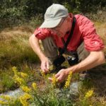
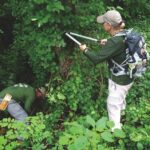
We rely heavily on volunteers to monitor and control invasive plants along the A.T. Each year, several workshops are held to educate people about these species and how to address the problem of invasive plants. We have adopted an inventory protocol modeled after the reporting guidelines on the Early Detection and Distribution Mapping Systems (EDDMapS) website. This user-friendly system allows us to collect and share data with all of its partners.

Once invasive plants are identified along the Trail, the ATC and volunteers organize work projects to control the highest priority infestations. Priority is given to areas where rare plants or other sensitive resources occur and where new invasive plant infestations can be easily controlled before they spread.

What​ are Invasive Species?

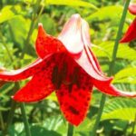
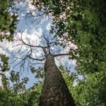
Non-native invasive species are those that do not naturally occur in a certain area and are capable of causing ecological damage when introduced into a native ecosystem. Not all non-native species are invasive, but some have the ability to spread rapidly without the natural enemies from their home range. This allows them to spread rapidly and out-compete native vegetation, which increases their ability to spread.

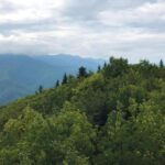
By invading healthy ecosystems, invasive plants can replace complex forest communities with single species mono-cultures and can reduce the diversity of food supply and habitats available for native wildlife. Invasive species can interfere with essential ecosystem processes such as nutrient cycling, water filtration and fire regimes. Invasive species diminish the ability of ecosystems to sustain economic activities like forestry, fishing and agriculture, and they reduce the aesthetic value of a naturally diverse landscape.

Non-native invasive species can be spread by water, wind and animals, but seeds can also be transported on the shoes, clothing, and equipment of Trail users. It is important to educate yourself about how recreational activities can contribute to the proliferation of invasive species.

American Chestnut monitoring

In 2008, we launched a volunteer-based pilot project with the American Chestnut Foundation (TACF) to document the presence of American chestnuts along the A.T. This survey of trees also works to identify the locations of flowering chestnut trees to aid chestnut breeding and restoration programs.

The American chestnut played a key role in forests throughout Appalachia before being devastated by a blight fungus imported with Asian chestnut trees in the early 20th century. The goal of this project is to gather information on the location and status of surviving remnants of the population and to gain insight on the environmental variables that affect the growth and survival of chestnut trees.

Data Collection

Data on large individual trees with the potential to produce flowers will assist TACF in increasing the genetic diversity of its backcross breeding program, which aims to produce an American chestnut with the blight-resistant characteristics of an Asian chestnut. Data on the density and location of American chestnut trees will be used to determine the environmental variables that affect the growth and survival of chestnut trees, which will help inform future reintroduction of blight-resistant American Chestnut trees in the Appalachian region.

Two types of data are collected: 

  • Total number of American chestnut trees three feet in height or taller within fifteen feet on either side of the trail, per defined trail segment
  • Location and description of large individual trees thirteen inches or greater in circumference at 4.5 feet above ground, per defined trail segment

​Learn more about our partnership with the American Chestnut Foundation.

Maps & Forms for Count Report