What to Look for While Looking at Your Feet on the Appalachian Trail

Apr 9, 2026

Apr 9, 2026

When asked, “What did you see while on the Appalachian Trail?” most will say a sweeping overlook, an exciting wildlife encounter, or fellow hikers. What we leave out of our highlight reel is likely the thing we spent the most time looking at while on the Trail: our own feet as we carefully place them over roots and rocks.
Often, we are looking down at the Trail, keeping our eyes peeled for obstacles that could trip us up. But if you’ve ever looked down and wondered about those rocks—what they are, how they got there, and why they change as you travel the Trail, this guide will help answer those questions and introduce you to the basics of Appalachian Trail geology, equipping you to identify some geologic features of the A.T.
The rocks under our soles tell a story much older than the Trail itself, showing the evolution of the Appalachian Mountains and just how long it took to form the ridgeline that is the foundation for the A.T.

The majority of the A.T. lies within three physiographic provinces, which are defined regions where certain rock types exist. This is a guide for understanding the two southern provinces, the Valley and Ridge province and Blue Ridge province. These provinces have the clearest boundaries that run straight in the A.T. landscape. They are also some of the easiest to delineate for budding Trail geologists. Both provinces hold keys to understanding how the ridgelines we know and love were formed about 750 million years apart.
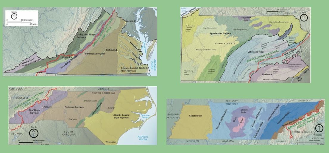
Clockwise Geologic Maps of Virginia, Pennsylvania, Tennessee, and North Carolina. Provinces labeled. Courtesy of USGS.
Both provinces are the result of tectonic plates colliding, leading to a mountain building event called an orogeny. The Valley and Ridge province is a result of the Alleghenian orogeny, which was a collision of the continents that are now known as North America and Africa around 250 million years ago. The result being sedimentary areas, where we find limestone, sandstone, and shale.
The Blue Ride goes even further back, beginning to form with the Grenville orogeny around 1 billion years ago. A series of collisions produced high grade metamorphic rocks like schist, gneiss, slates, quartzites, with occasional igneous intrusions.
Understanding the provinces helps hikers piece together clues about the rocks and geologic features under their feet. So, how do you determine which province you’re in on the Trail?
First, zoom out. What does the bigger picture look like? All hikers should carry a map, so take a look at the elevations around you. Are you in an area where the mountains look more like isolated knobs surrounded by sister mountains, or are you on a lengthy ridgeline separated by vast valleys? A great example is the view seen from Dragons Tooth or McAfee Knob. From those spots, hikers look over large valleys from a sandstone ridgeline.
True to its name, you will find stretching ridgelines with distinct valleys in the Valley and Ridge province. Meaning you are most likely identifying a sedimentary rock. If you see more rounded peaks that appear as individual mountains you are probably in the Blue Ridge province.
Once you’ve identified the province, you can begin to make more educated guesses about the specific rocks you’re seeing. Observation is the key to becoming a Trail geologist. Find a rock you’re curious about and take note of the shape, color, and texture. Is the rock one solid color, does it have sparkling bits? Is it multicolor?
When in the Valley and Ridge province, hikers will primarily encounter matte rocks with less variation in color. These rocks will likely have a flat, planar shape.
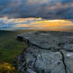
Hikers on a ridge will likely find sandstone or shale. Shale is easier to identify and looks like gray sheets that have been pressed together. It can be lighter shades of brown as well, but it will always have small visible grains and will chip very easily.
Photo: Sandstone formation showing planar behavior of Valley and Ridge formations near Newport, VA.
Sandstone is a broader category. The ridgelines that make up the Valley and Ridge province are primarily sandstone. Iconic views such as McAfee Knob and Dragons tooth are perfect examples of the sandstone found along the A.T. Sandstone appears more cubic, breaking off in pieces with more dimension than flat shale.
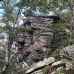
Sandstone is also a much more colorful rock. Once weathered, it will usually appear gray, but when walking along the Trail, keep your eyes peeled for pinks, yellows, browns, and even orange. When you put your eye up to a sandstone you will see pieces of sand pressed together to make the rock.
Photo: Weathered sandstone along the Trail itself.
The Blue Ridge province is slightly more nuanced, and the extensive history makes for a complex geologic profile. Hikers in the Blue Ridge will find more crystalline rocks. These have been formed by hotter temperatures than the rocks found in the Valley and Ridge province, so they will be more of one body as opposed to granular pieces.
In this region, quartzite is likely the easiest to identify as it is primarily white and has a glassy texture. It is the product of either sandstone or quartz that has undergone some metamorphism (changes to a rock’s structure due to high pressure, temperature, or chemicals).
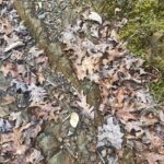
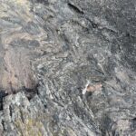
While quartzite is the most recognizable in this province, the most common rock that hikers will encounter in the Blue Ridge is gneiss. Gneiss is a highly metamorphosed rock that takes on many appearances. It will usually appear as a striped rock with very clear dark and light sections. When these are on the Trail, they will look like multicolor rocks with sparkling bits of mica, light sections of quartzite and feldspar, with dark sections made of magnesium rich minerals.
The Blue Ridge has another special section that observant hikers may notice. During their over 1.2-billion-year evolution, they had magma bodies rise up from the mantle and into the existing rock bodies. These are called igneous intrusions and are responsible for the erosion resistant peaks that define the Blue Ridge.
Mount Rogers and the surrounding Grayson Highlands in Virginia are examples of igneous intrusions. With fewer years of pushing and pulling during metamorphism, the peaks are stronger, taller, and make a great foundation for the A.T.’s treadway. These intrusions look similar to gneiss because they are similar rock, just a slightly different age.
Photo: Distinct bands making up metamorphic gneiss in Southern Appalachia.
Next time you find yourself wondering about all of the rocks below your feet on the Trail, remember this guide, and how long it took for those rocks to get there.
The Appalachian Trail was conceived by Benton MacKaye in 1921 and completed in 1937. On a human scale, this makes the Trail seem fairly old. Approximately four generations have passed since the Trail originated. However, the geologic scale of the Appalachian Mountains — the actual bedrock of the Trail and its surrounding lands — extends far beyond this human scale, back hundreds of millions of years.
Visiting the Appalachian Trail is an invitation to consider the ancient processes that formed the ground beneath your feet, and to know that you and every other A.T. hiker can be part of a legacy to care for one of the most enduring landscapes on our planet. Be sure to practice Leave No Trace any time you visit the Trail, and always leave the rocks you find so that others can observe them too.
Source: Appalachian National Scenic Trail Geologic and Soil Resources Inventory Summary
Give today to get your limited-edition 2027 calendar featuring breathtaking scenes from the Trail.
Reserve my calendar