Appalachian Trail Becomes a Half Mile Longer in 2026
Dec 4, 2025

Dec 4, 2025


The total length of the A.T. typically changes slightly each year due to footpath relocations and more precise measurement techniques. While the Appalachian Trail Conservancy announces the official mileage annually, it’s important to remember that this number is just a snapshot in time. The A.T. is constantly evolving as Trail Maintaining Clubs, the ATC, and our partners complete work on the footpath. Detours may be added or removed, and extreme weather events may shift sections of the Trail at any time.
Still, the official 2026 mileage is what will appear on 2026 hiker hangtags and currently best reflects the route that 2026 hikers will walk. Learn more about the sections that changed this year and how those updates influence the Trail’s total mileage for 2026.
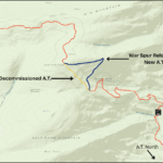
The one-mile War Spur relocation moved the footpath from a steep, half-mile fall-line route to a more sustainable grade. A fall-line route is one where the footpath goes straight up an incline, allowing water to flow directly down the path, eventually eroding the Trail into a rocky gully. The gentler grade of the relocation will help the footpath in this section last longer. The relocation also now winds the A.T. through some interesting rock features.
View Larger MapThe multi-year project was completed by the ATC’s Konnarock Trail Crew, volunteers with the Roanoke Appalachian Trail Club, and crews with the Southern Appalachian Wilderness Stewards (SAWS), with support from the U.S. Forest Service.
Interested in being part of projects like this? Consider joining an ATC Trail Crew for a few days on the Trail in 2026!
Four detours are now in effect on the A.T. that were not incorporated into the official mileage of the Trail for 2026. Temporary detours are generally not included in the mileage, and hikers have several options for getting around the closed sections at most of these detours.
The Great Gulf Detour routes hikers away from the closed Madison Gulf Bridge, which carries the A.T. across the West Branch of the Peabody River. The bridge was closed by the U.S. Forest Service late in 2024 due to structural failure. The full detour route is 6.4 miles and uses the Great Gulf and 19 Mile Brook trails, bypassing Pinkham Notch and the Wildcat Range.
However, hikers may choose to take the AMC Hiker Shuttle between Pinkham Notch and the 19 Mile Brook trailhead (offered for free to thru-hikers) or arrange their own ride.
For updates, more information, and a map of the detour, visit our Great Gulf Detour alert.

Caitlin Miller
The Iron Mountain Gap Detour routes hikers around severe damage caused by Hurricane Helene in September 2024. A project to remove storm debris is ongoing in the closed section. Hikers must use the detour, which is currently about 6 miles, while the section remains closed. Taking the detour is essential for the safety of hikers and the crews working.
For updates, more information, and a map of the detour, visit our Iron Mountain Gap Detour alert.

Jake Stowe
Hurricane Helene destroyed the road bridge that carried the A.T. across the Nolichucky River, just outside of Erwin, Tennessee. The ATC, U.S. Forest Service, and officials with the Town of Erwin and Unicoi County have been working with the Tennessee Department of Transportation on plans for the new bridge. Hikers can either follow the road walk detour (3.6 miles) or shuttle around.
For updates, more information, and a map of the detour, visit our Nolichucky River Detour alert.

John Henkelman
This detour is also a result of Hurricane Helene, which severely damaged the Virginia Creeper National Recreation Trail (Creeper Trail). The A.T. will be closed during construction where it is co-aligned or closely parallels the Creeper Trail.
During the closure, A.T. hikers have two options: they can “retro blaze” on a detour that partly follows the Iron Mountain Trail, which was the A.T.’s route until 1972 and still features two historic shelters, or they can shuttle around the closed section.
For updates, more information, and a map of the detour, visit our Virginia Creeper Trail Detour alert.

Jim Baum
No matter how many miles of the A.T. you plan to hike in 2026, we hope you will join us in thanking the hardworking Clubs, crews, and volunteers who worked quickly to clear the Trail after Hurricane Helene and made these needed improvements and relocations possible.
If you’re planning to visit the A.T. in 2026, whether for a few nights or a few months, please consider registering your hike on ATCamp.org to receive urgent safety updates and help reduce overcrowding on the Trail.
As always, your support is essential for keeping all 2,197.9 miles of the Trail alive.

Kathryn Herndon-Powell

Your gift for the A.T. will go 2x as far with the 2,000-Miler Match!
A group of 2,000-Milers are matching every gift made to the ATC up to $101,000 before 3/31.
Give Now