Hike Description
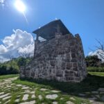
This national historic landmark offers panoramic views of many mountain ranges and two valleys. From the tower, one can see the main ridge of the Smoky Mountains to the North, the Balsams and the Cowees to the East, and the Tusquittee and Slickrock ranges to the West. To get there, follow the paved path up from the parking lot.
The paved path reaches almost to the base of the tower and is ADA accessible, with an approximate grade of 8%. There are beautiful views to the east as the path ascends. The final 30 feet or so to the tower itself is made of flat, individual paver stones, with some grass visible between stones. There are stone steps leading up the tower to the viewing platform.
There are accessible vault toilets on the side of the parking lot. There is no running water.
Directions
From Franklin, drive four miles west on US 64 and turn right at the Wayah Bald sign. Take the first left onto Wayah Road (NC 1310). Stay on NC 1310 for 9.1 miles as it winds to the top of the hill (Wayah Gap). Turn right on the gravel road (Forest Service Road 69) to Wayah Bald. Go about 4.5 mi to the parking area near the end of road.