Hike Description
- From the main road at Massie Gap, hike 0.5 mile on the blue-blazed Rhododendron Trail to the A.T. Turn left and follow the A.T. south.
- Hike another 0.5 mile and cross a fence, leaving Grayson Highlands State Park behind and entering the Jefferson National Forest.
- Reach the junction with a blue-blazed side trail in 0.25 mile. Follow this trail, which leads straight up and over Wilburn Ridge to rejoin the A.T. on the other side of the two highpoints on the ridge.
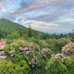
- After rejoining the A.T., continue south and descend to Rhododendron Gap. After exploring the gap (there is a nice view from the rocks), hike back north on the A.T., which bears left around the high points on Wilburn Ridge.
- At the junction with the Rhododendron Trail, turn right and return to the parking area.
Directions
From I-81 near Marion, follow the signs to Grayson Highlands State Park. The park is just north of the Virginia-North Carolina border on US 58, 8 miles west of the community of Volney. Once in the park, follow the main park road to the trailhead at Massie Gap.
Note that this is a very popular hiking area and parking fills up quickly. Parking in the grass along the road shoulder may result in a fine. Carpool when possible and have a back-up hike planned in case the parking is full when you arrive. Overnight parking in Grayson Highlands State Park for backpacking requires a reservation.