Note that a campground reservation is required for overnight stays in Baxter State Park. For more info about the park and planning your trip, visit the park’s website.
Trail Description
- Walk from Daicey Pond Campground back to the A.T. and turn left. A side trail to the right at 0.9 mile leads to the Toll Dam across Nesowadnehunk Stream. From the late 1800s to mid-1900s, the waterway played a major role in Maine’s timber industry, because logs were floated downstream to the West Branch Penobscot River. The dam, first built in 1879, helped control water flow for the log drives.
- A few hundred feet south of the dam side trail is another pathway to the right, leading in less than 100 yards to Little Niagara Falls. Stanchions, used as part of the 1800s apparatuses to get logs over the falls, are still visible.
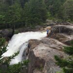
- At 1.1 miles into the hike is a short side trail to a spring; less than 0.2 mile later is the trail, right, to Big Niagara Falls. The falls drops noisily into its basin, with large granite outcrops providing grandstand seats from which to watch the spectacle.
- Retrace your steps back to the campground.
Directions
You will cross the A.T. just before you reach the Daicey Pond Campground, located about 1 mile off the perimeter road in Baxter State Park and about 11 miles from the Togue Pond Gate. The gate is located approximately 20 miles from Millinocket, via the Baxter Park Road.
Download Baxter State Park Map