Hike Description
- From the trailhead, follow the blue-blazed trail into the gorge. At mile 0.4, pass “Buckled Rock,” a rock cliff across and above the stream.
- Hike another 0.6 mile to the junction with the white-blazed A.T. Follow the A.T. southbound (east), hiking upstream along Laurel Fork for 0.25 mile, and cross the stream twice on footbridges. The Trail beyond the bridge climbs and briefly follows a ridge where there are good views of the gorge.
- Reach the junction with the side trail to Laurel Fork Shelter (note that the shelter itself burned down in 2024). The Trail then drops down off the low ridge and at mile 2.3, skirts the base of a cliff on a built-up section of trail.
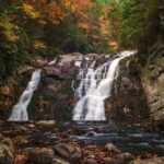
- Hike another 0.25 mile to the base of Laurel Falls (swimming in pool below falls may be hazardous).
- Retrace your steps to complete the hike.
Directions
The Forest Service gravel trailhead parking lot is on the east side of Hampton, about 1.5 miles from US 19E, along US 321, just beyond where US 321 crosses Laurel Fork on a bridge. The blue blazed trail into the gorge leaves the south end of the lot.