Hike Description
- From the A.T. crossing at Lakes Road (Monroe Road), the footpath descends and crosses a wood truss bridge over Trout Brook.
- In 0.25 mile, cross another brook, turn left and follow the brook through a hemlock grove. Because this area is frequently flooded, there is a blue-blazed bypass trail to avoid the crossing of two more brooks in wet weather. The side trail ascends to the right through hemlocks and rejoins the A.T. after 0.1 mile at Fitzgerald Falls.
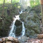
- Crossing the stream just below the falls, climb steeply up rock steps alongside the falls. At mile 0.75, pass some stone walls to the left. These are the remains of an abandoned settlement.
- Slightly more than 0.5 mile later, make a left turn before climbing steadily 0.1 mile later. At mile 1.5, at the top of a rise, the blue-blazed Allis Trail heads off to the right, named for an early treasurer of the ATC. A viewpoint is located a short distance north on the Allis Trail. From the viewpoint, High Point Monument in New Jersey and Mount Tammany at the PA-NJ border are visible to the west.
- The Trail levels off here and reaches Mombasha High Point in another 0.75 mile. The view to the left is of Mombasha Lake with Schunemunk Mountain behind it to the northeast. Harriman State Park is to the east. New York City can be seen on the southern horizon on clear days, and Bellvale Mountain is to the west.
- Retrace your steps to complete the hike.
Directions
To reach the A.T. crossing, take Lakes (Monroe) Road out of Greenwood Lake and travel about 4 miles.