Hike Description
- From the small parking area head diagonally across the Blue Ridge Parkway to hike south on the A.T., and begin climbing the northeast slope of Punchbowl Mountain.
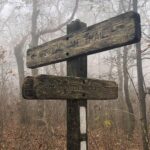
- At mile 0.4, reach the junction with the blue-blazed side trail, which leads 0.2 mile to Punchbowl Shelter (the ascent is steep, but the Trail is graded well and the climb is short). Take a side trip to the shelter if you choose, then continue on the A.T., and in 0.5 mile reach the tree covered summit of Punchbowl Mountain.
- Descend 0.25 mile to a gap and begin climbing Bluff Mountain. At mile 2, reach the summit of Bluff Mountain. Note the plaque in memory of Ottie Cline Powell just a few feet to the south.
- Retrace your steps to complete the hike.
Directions
The parking area is at Blue Ridge Parkway milepost 51.7, about 6.1 miles south of US 60 and about 12.2 miles north of US 501.